Sedimentology, Provenance and Radiometric Dating of the Silante Formation: Implications for the Cenozoic Evolution of the Western Andes of Ecuador

 ,
,  ,
,
Abstract
:1. Introduction
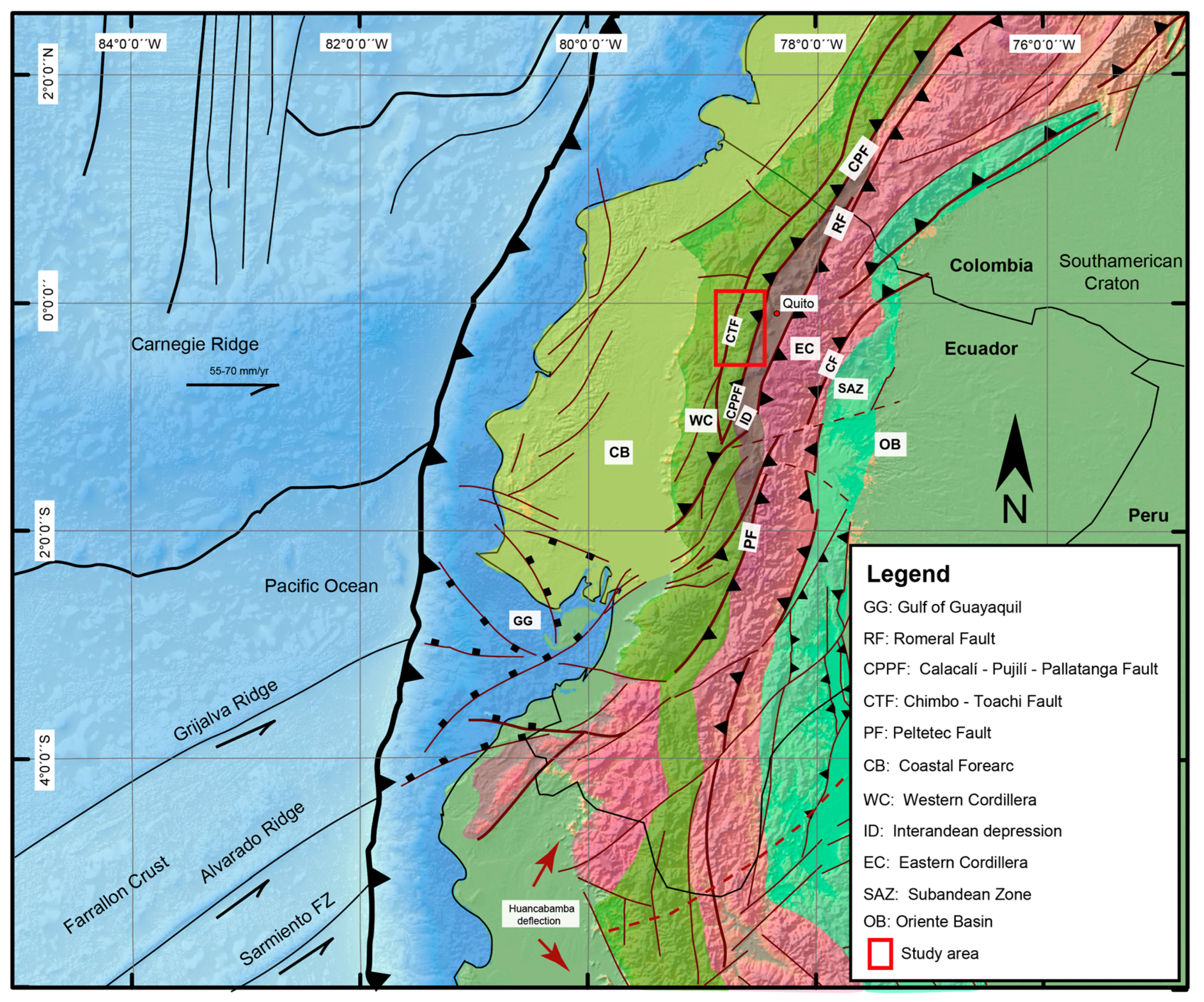
2. Regional Geology
2.1. The Western Cordillera
2.2. The Pallatanga Block and the Allochthonous Basement of Western Ecuador
2.3. The Yunguilla Formation
2.4. The Tandapi Unit
2.5. The Angamarca Group and the Pilalo Formation
2.6. The Oligocene to Miocene San Juan De Lachas Continental Arc
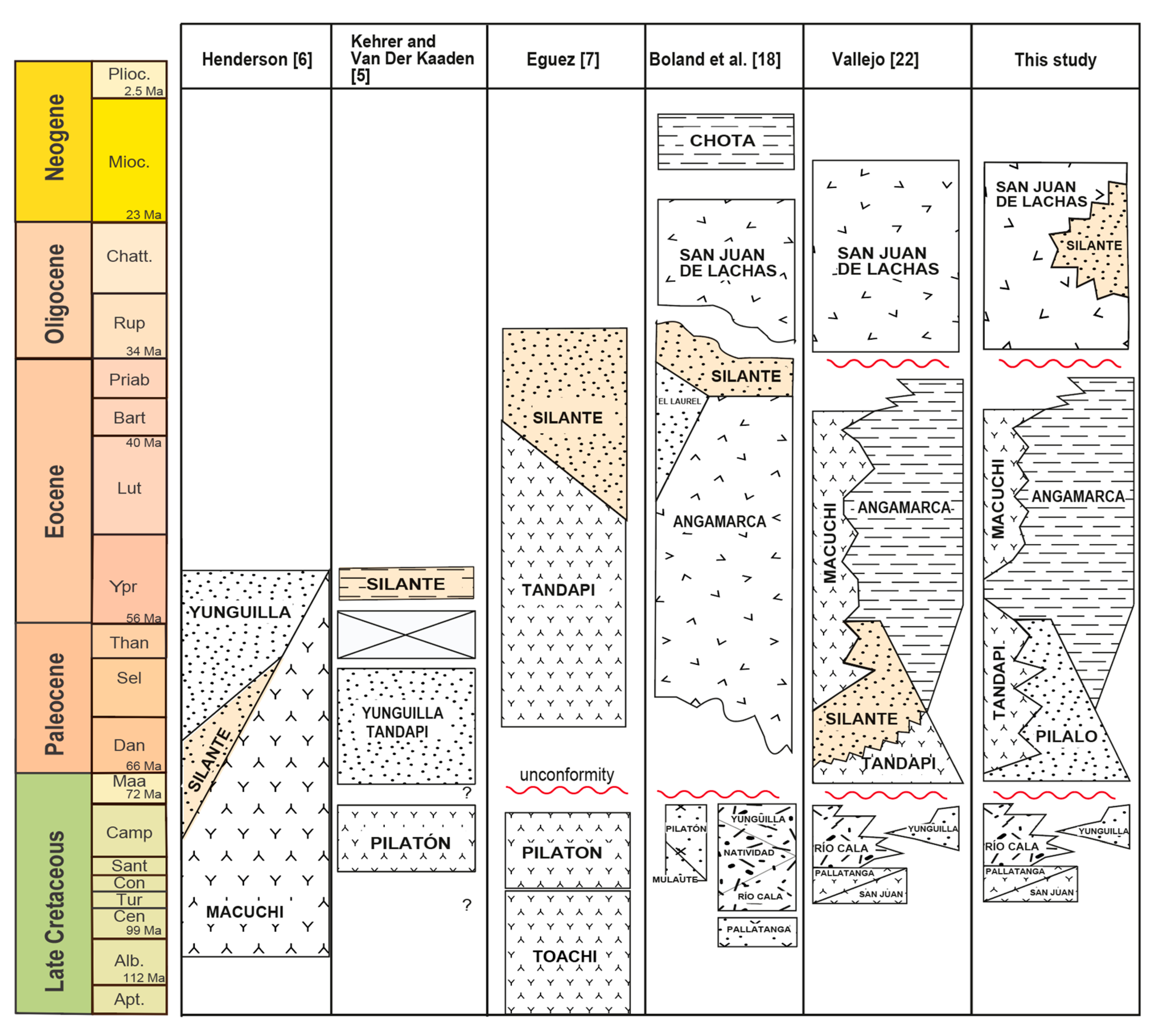
3. The Silante Formation and Its Stratigraphic Problem
4. Methodology
5. Results
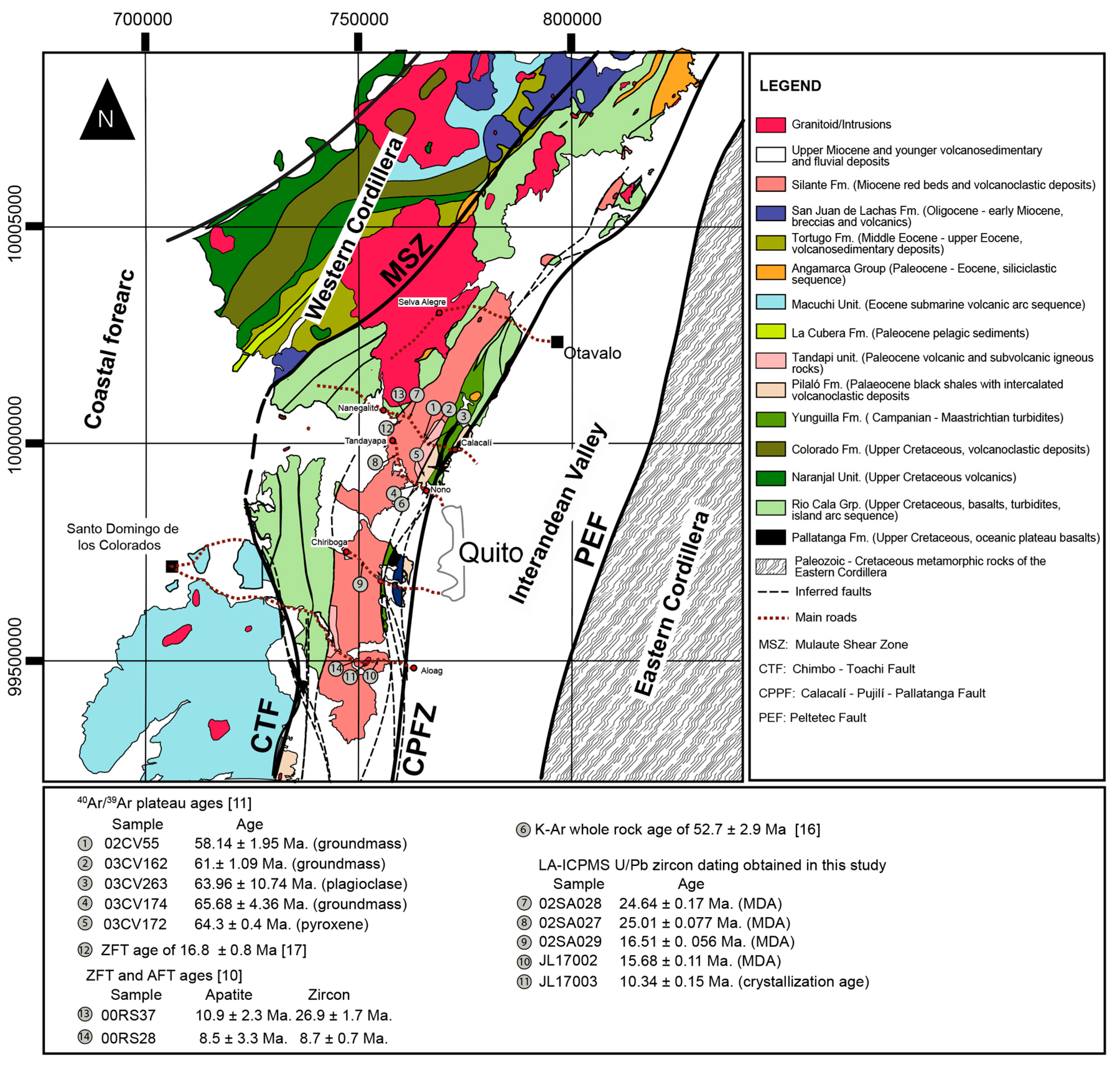
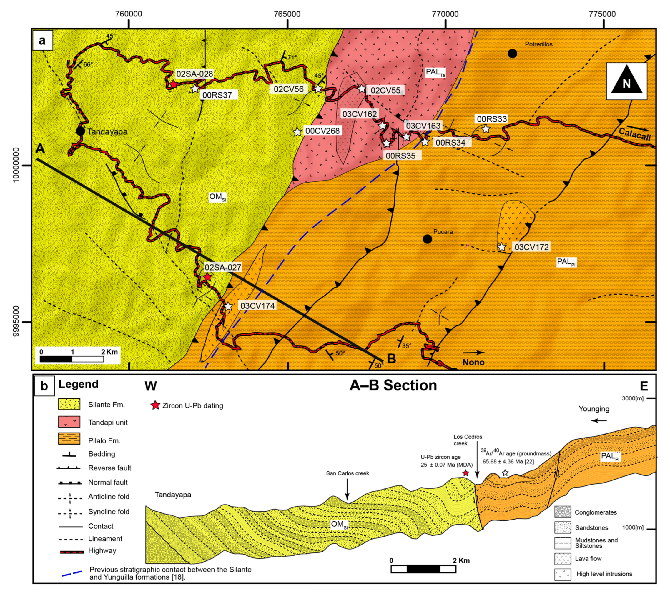
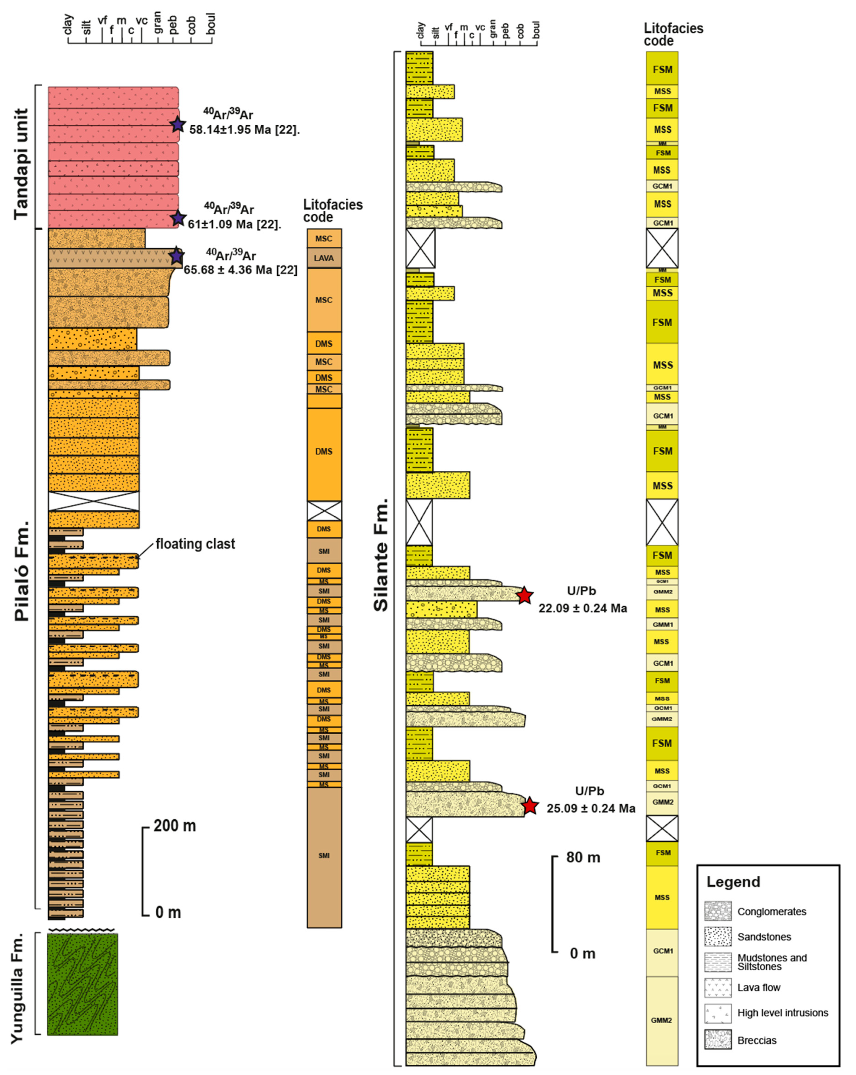
5.1. Stratigraphy of the Nono–Tandayapa and Calacalí–Nanegalito Road Sections
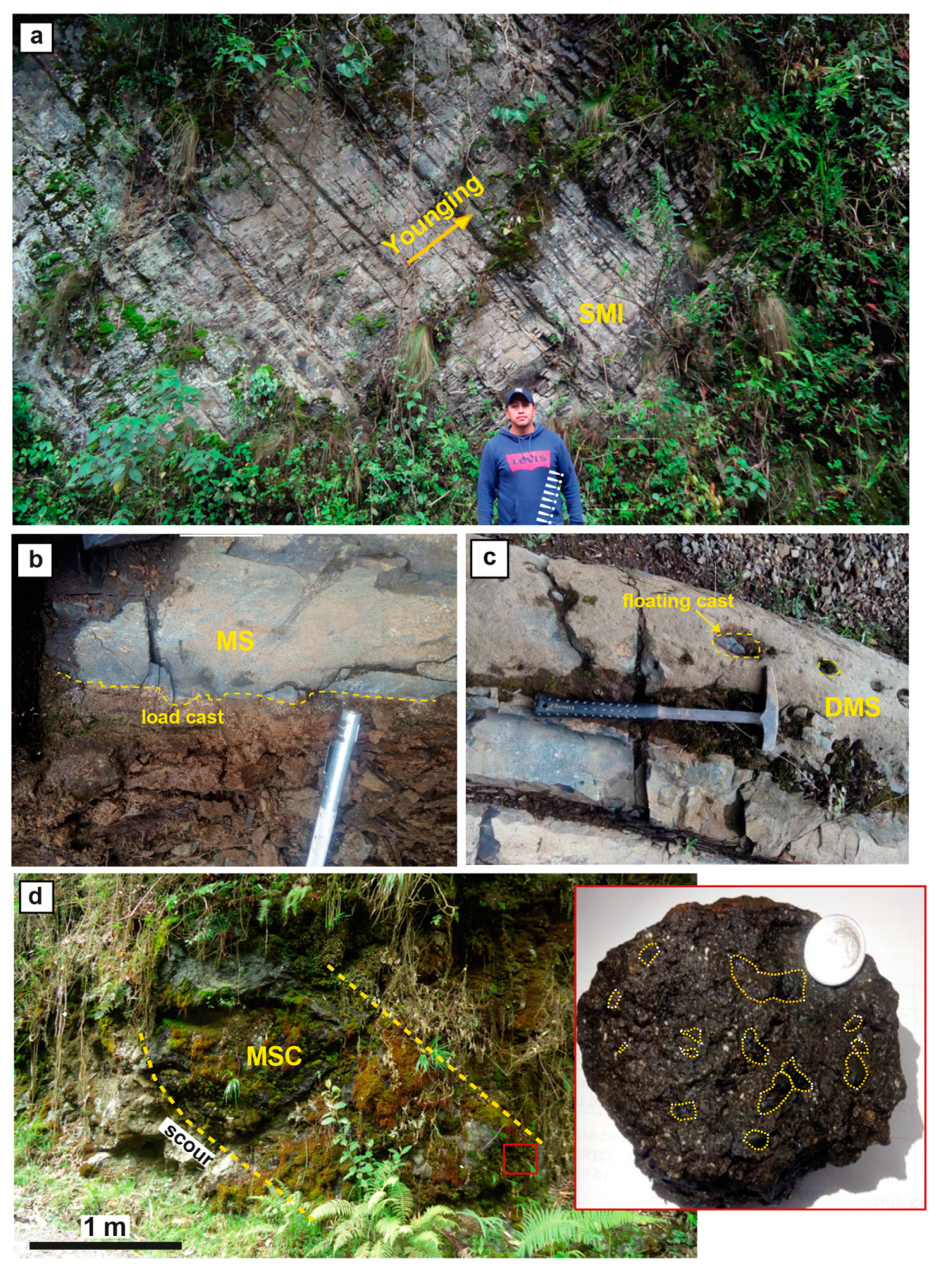
5.2. Sedimentology of the Pilalo Formation
5.2.1. Lithofacies SMI: Siltstones with Mudstone Intercalations
5.2.2. Lithofacies MS: Massive Sandstones with Load Cast
5.2.3. Lithofacies DMS: Massive Sandstones with Floating Clasts
5.2.4. Lithofacies MSC: Matrix-Supported Conglomerates
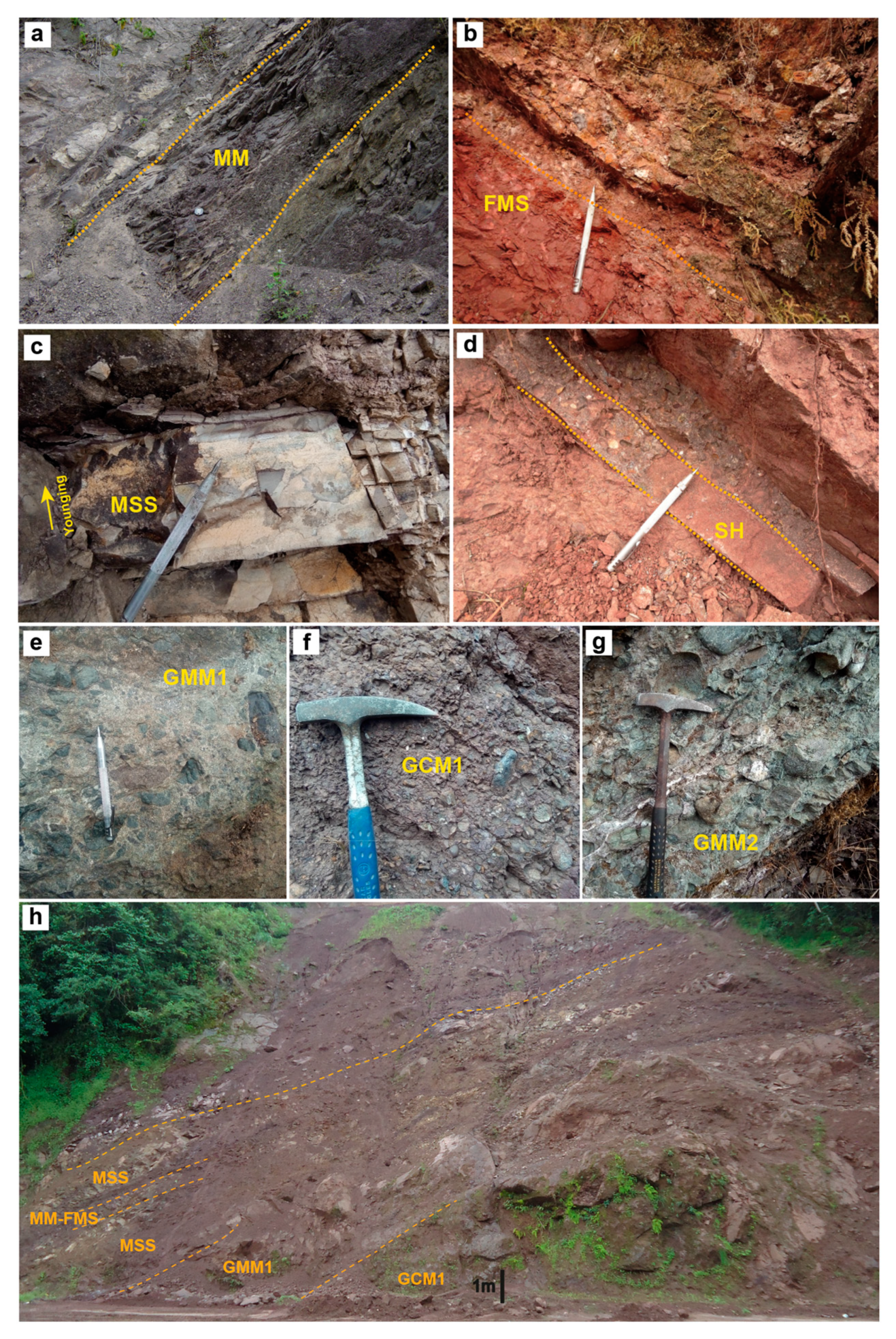
5.3. Sedimentology of the Silante Formation
5.3.1. Lithofacies MM: Mudstones
5.3.2. Lithofacies FMS: Massive Siltstones
5.3.3. Lithofacies MSS: Massive Sandstones
5.3.4. Lithofacies SPL: Sandstones with Parallel Lamination
5.3.5. Lithofacies GMM1: Massive Matrix Supported Conglomerates
5.3.6. Lithofacies GCM1: Massive Clast Supported Conglomerates
5.3.7. Lithofacies GMM2: Matrix Supported Conglomerates
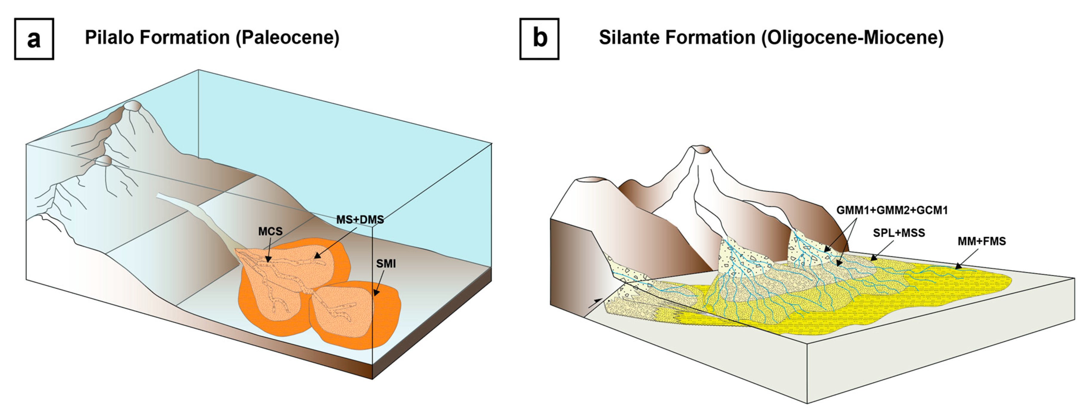
5.4. Depositional Environment of the Pilalo and Silante Formations
5.5. Provenance Analysis of the Pilalo and Silante Formations
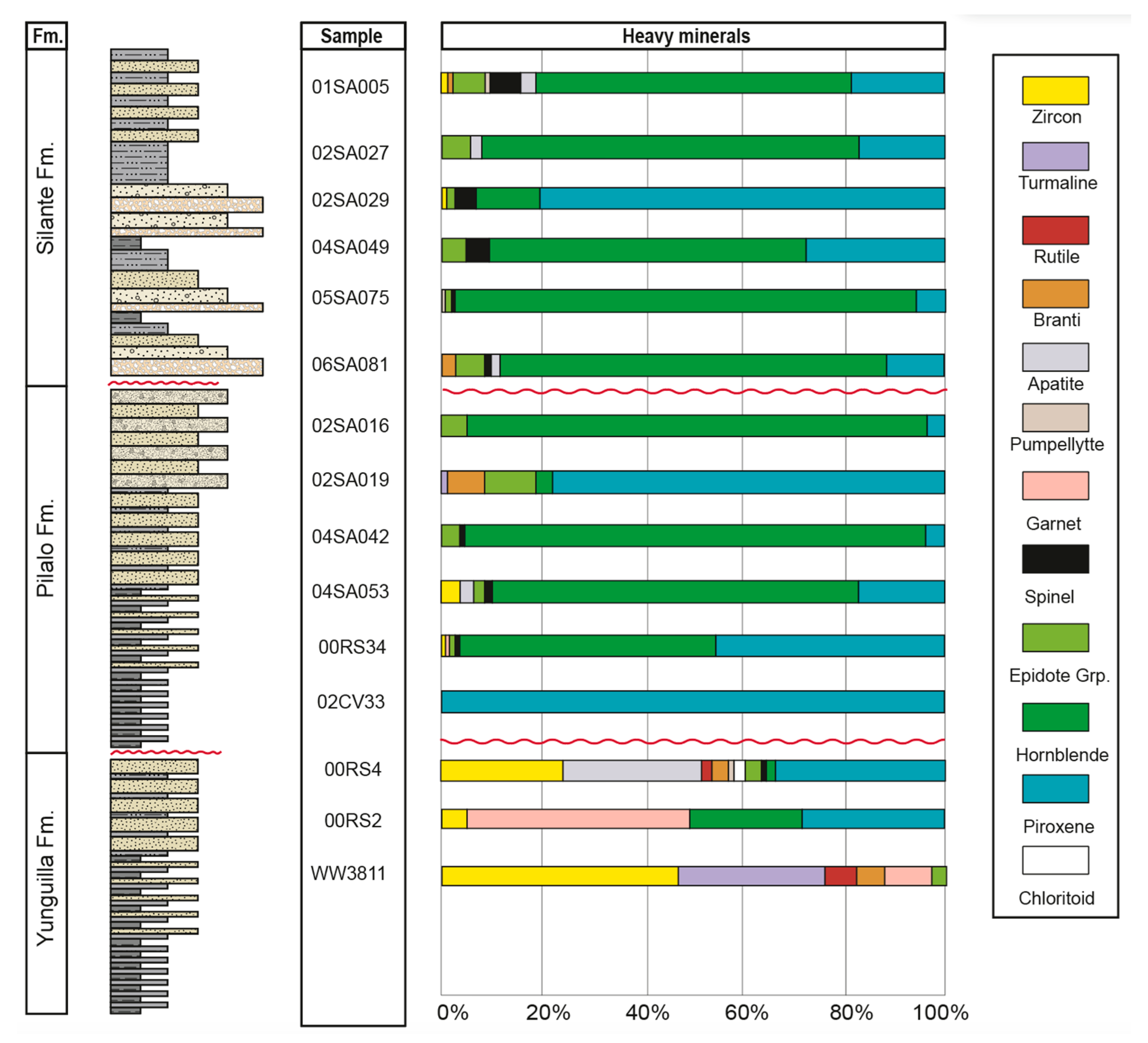
5.6. Heavy Mineral Data
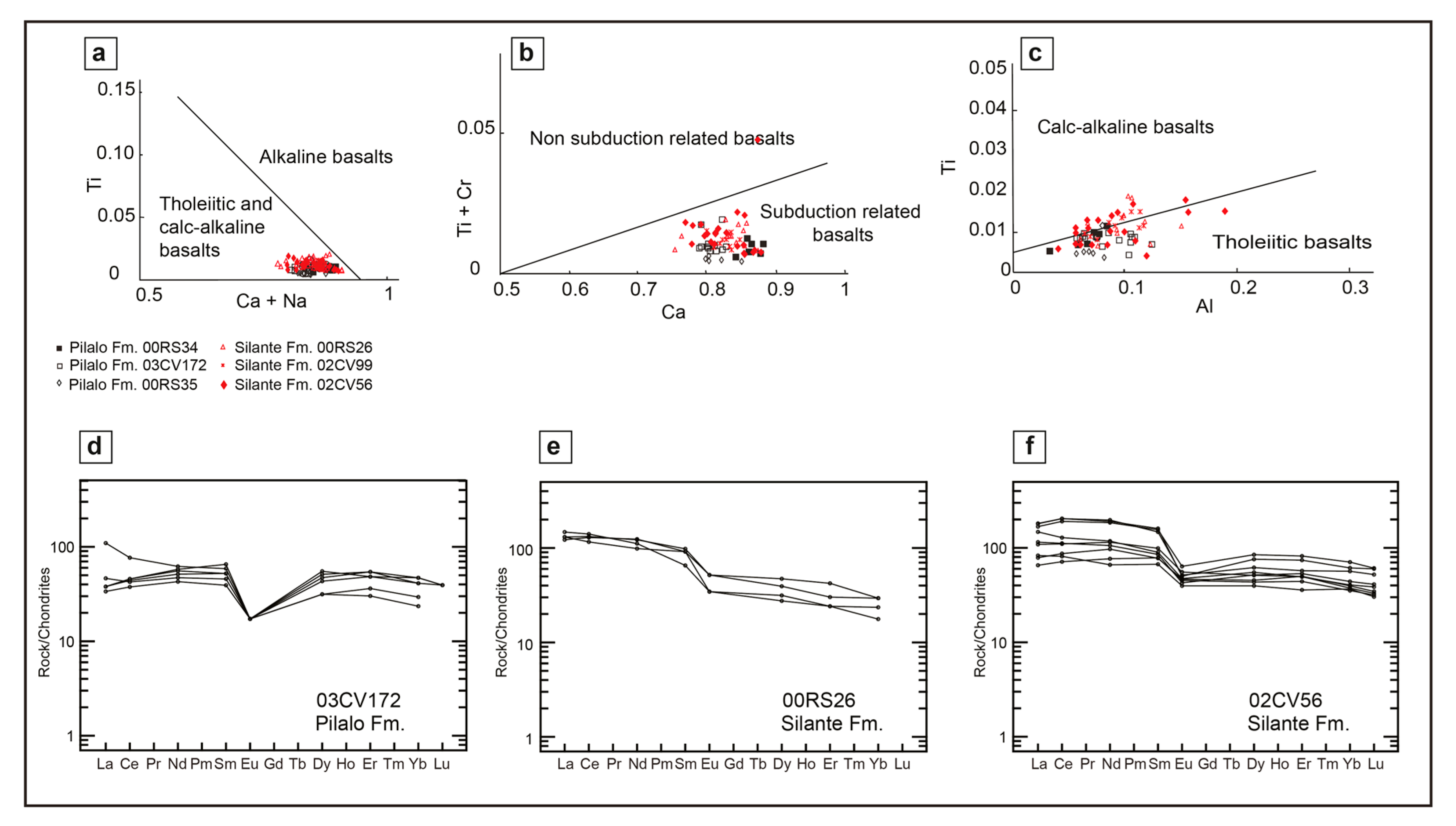
5.7. Clinopyroxene Single Grain Geochemistry of the Pilalo and Silante Formations
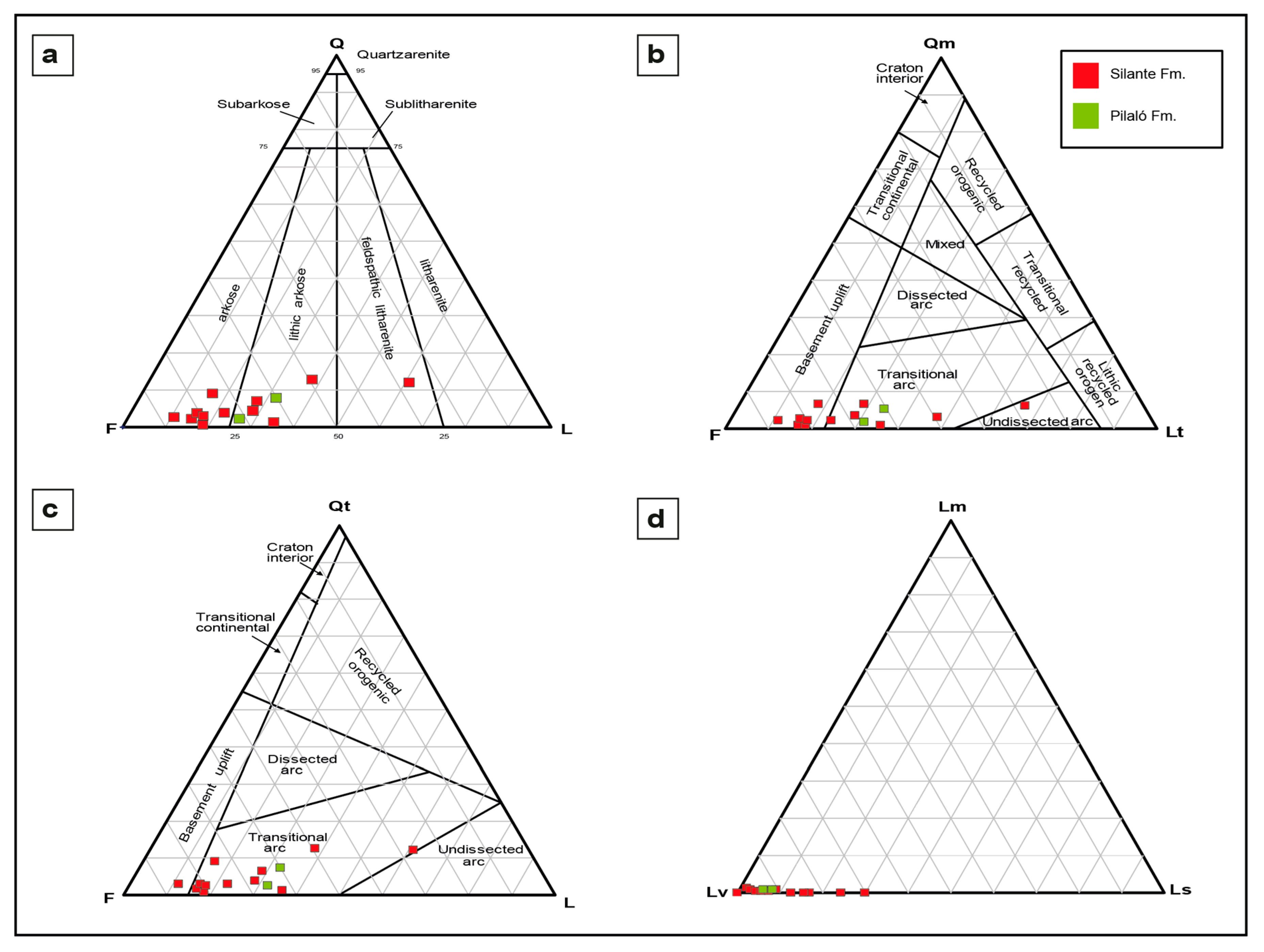
5.8. QFL Analysis (Quartz-Feldspar-Lithic Fragments)
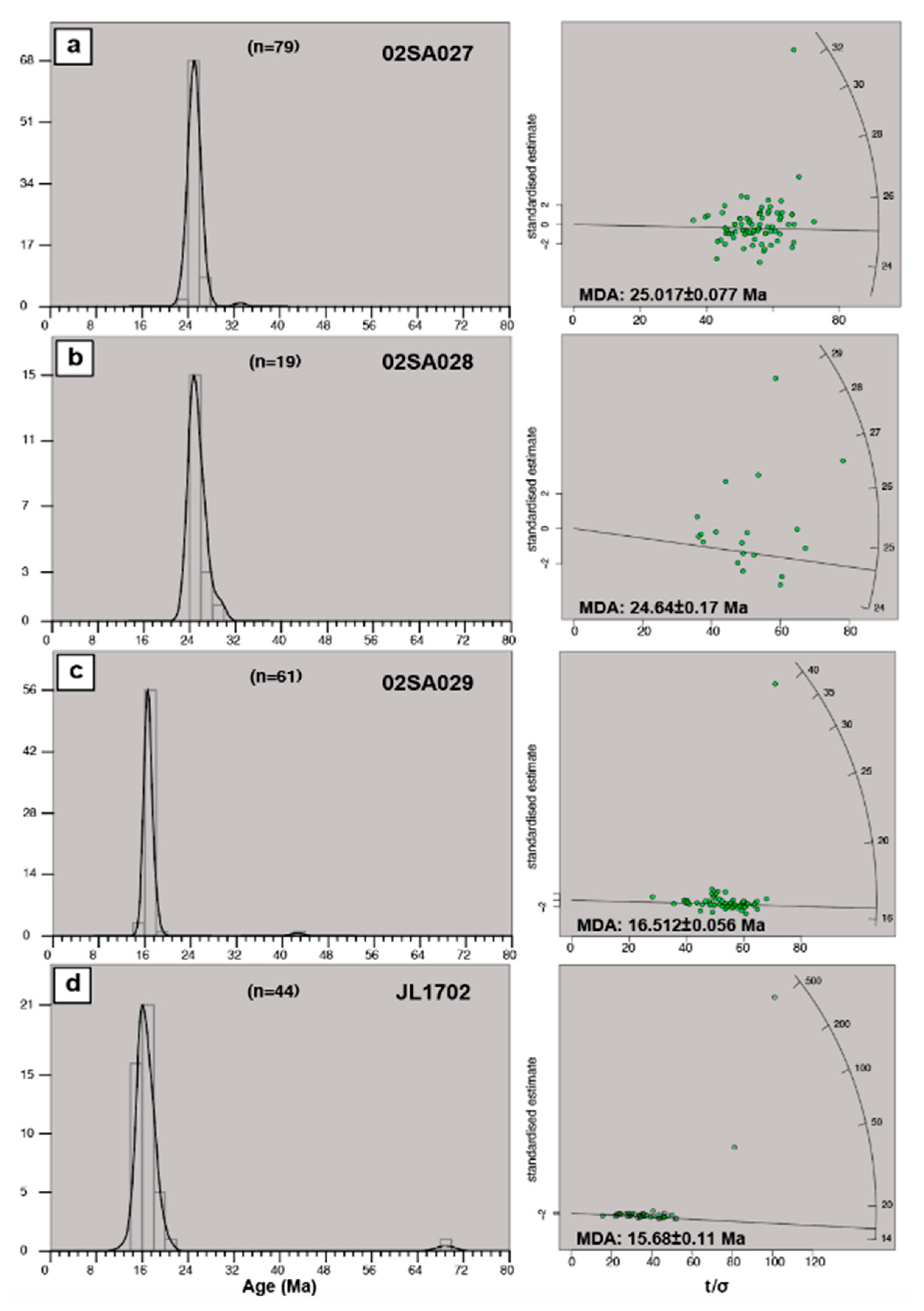
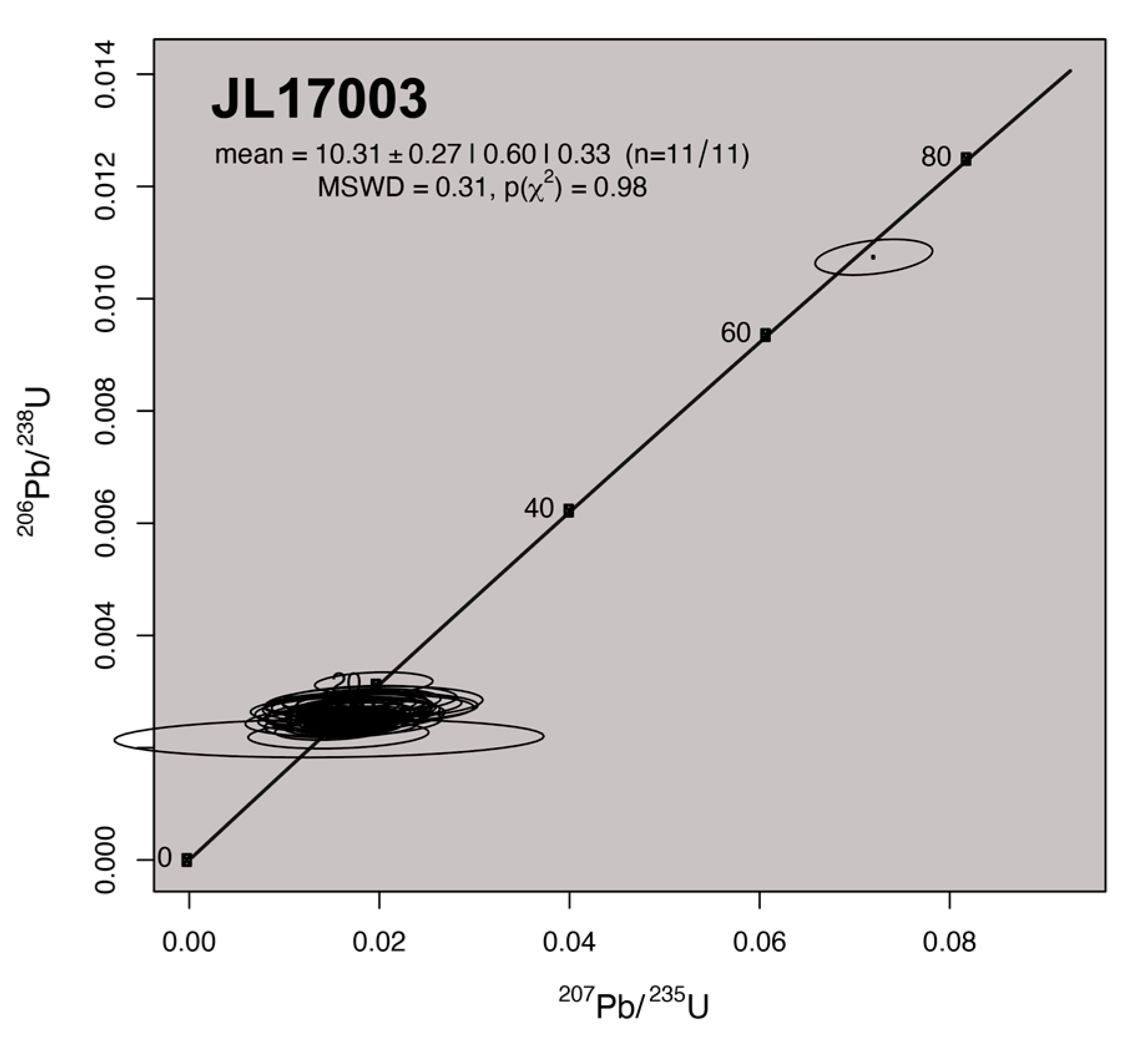
5.9. U-Pb Ages of the Silante Formation
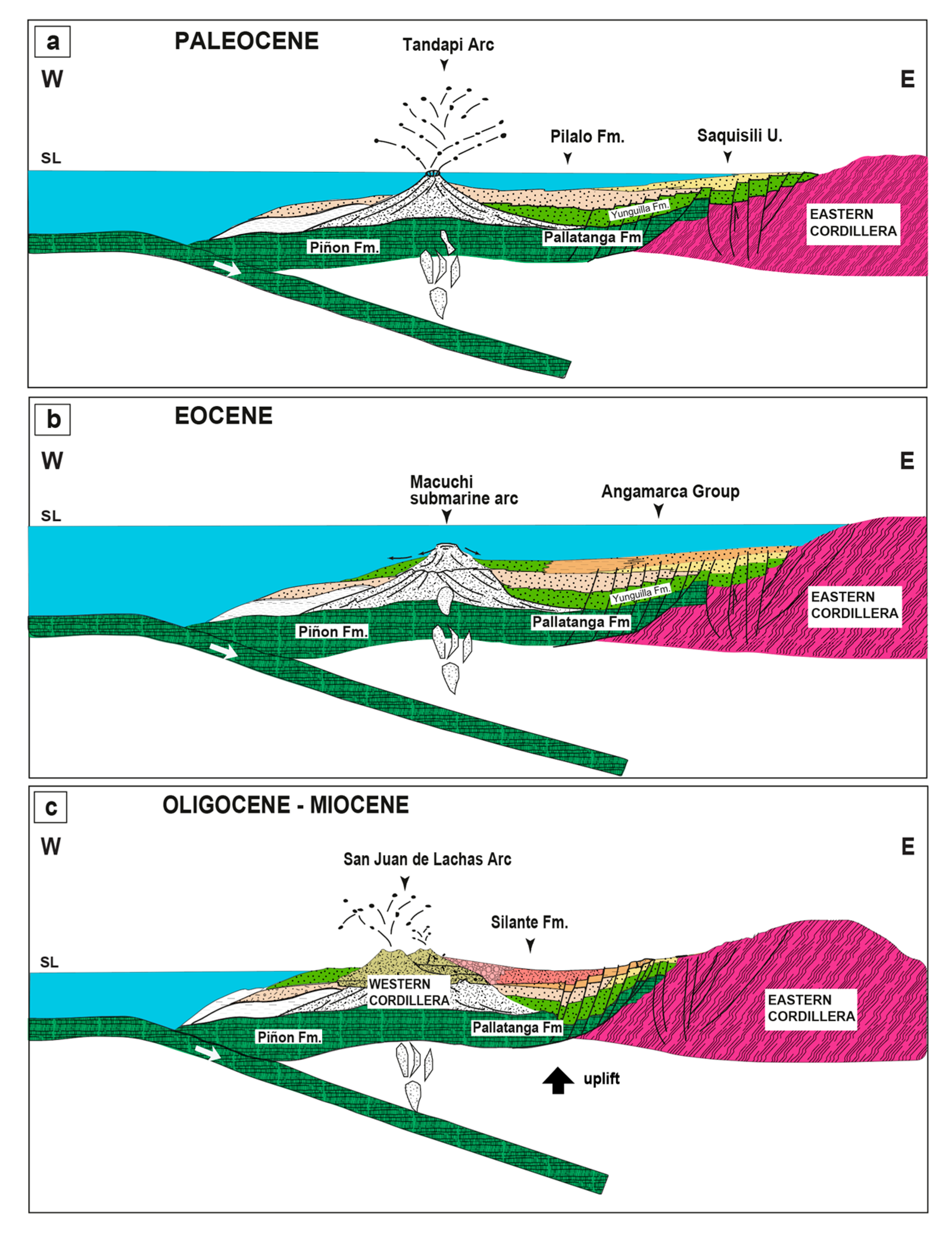
6. Discussion: Paleogeographic and Paleotectonic Model
7. Conclusions
Supplementary Materials
Author Contributions
Funding
Acknowledgments
Conflicts of Interest
References
- Luzieux, L.D.; Heller, F.; Spikings, R.; Vallejo, C.F.; Winkler, W. Origin and Cretaceous tectonic history of the coastal Ecuadorian forearc between 1° N and 3° S: Paleomagnetic, radiometric and fossil evidence. Earth Planet. Sci. Lett. 2006, 249, 400–414. [Google Scholar] [CrossRef]
- Vallejo, C.; Spikings, R.A.; Horton, B.K.; Luzieux, L.; Romero, C.; Winkler, W. Late Cretaceous to Miocene stratigraphy and provenance of the coastal forearc and Western Cordillera of Ecuador: Evidence for accretion of a single oceanic plateau fragment. In Andean Tectonics, 1st ed.; Horton, B., Folguera, A., Eds.; Elsevier: Amsterdam, The Netherlands, 2019; pp. 209–236. [Google Scholar]
- Feininger, T.; Bristow, C.R. Cretaceous and Palaeogene geologic history of Coastal Ecuador. Geol. Rundsch. 1980, 69, 40–44. [Google Scholar] [CrossRef]
- Chiaradia, M. Adakite-like magmas from fractional crystallization and melting-assimilation of mafic lower crust (Eocene Macuchi arc, Western Cordillera, Ecuador). Chem. Geol. 2009, 265, 468–487. [Google Scholar] [CrossRef]
- Kehrer, W.; Van Der Kaaden, G. Notes on the geology of Ecuador, with special reference to the Western Cordillera. Geol. Jahrb. 1979, 35, 5–57. [Google Scholar]
- Henderson, W.G. Cretaceous to Eocene volcanic arc activity in the Andes of northern Ecuador. J. Geol. Soc. Lond. 1979, 136, 73–78. [Google Scholar]
- Egüez, A. Evolution Cenozoique de la Cordillere Occidentale Septentrionale d’Equateur (0°15′ S–01°10′ S) les Mineralisations Associetees. Ph.D. Thesis, University of Pittsburgh Medical Center, Paris, France, 1986. [Google Scholar]
- Kerr, A.C.; Aspden, J.A.; Tarney, J.; Pilatasig, L.F. The nature and provenance of accreted oceanic Blocks in western Ecuador: Geochemical and tectonic constraints. J. Geol. Soc. 2002, 159, 577–594. [Google Scholar] [CrossRef]
- Jaillard, E.; Ordoñez, M.; Suarez, J.; Toro, J.; Iza, D.; Lugo, W. Stratigraphy of the late Cretaceous Paleogene deposits of the cordillera occidental of central Ecuador: Geodynamic implications. J. S. Am. Earth Sci. 2004, 17, 49–58. [Google Scholar] [CrossRef] [Green Version]
- Spikings, R.A.; Winkler, W.; Hughes, R.A.; Handler, R. Thermochronology of Allochthonous Blocks in Ecuador: Unraveling the accretionary and post-accretionary history of the Northern Andes. Tectonophysics 2005, 399, 195–220. [Google Scholar] [CrossRef]
- Vallejo, C.; Winkler, W.; Spikings, R.A.; Luzieux, L.; Heller, F.; Bussy, F. Mode and timing of terrane accretion in the forearc of the Andes in Ecuador. In Backbone of the Americas: Shallow Subduction, Plateau Uplift, and Ridge and Terrane Collision, 1st ed.; Kay, S., Ramos, V., Dickinson, W., Eds.; Geological Society of America Memoirs: Boulder, CO, USA, 2009; Volume 204, pp. 197–216. [Google Scholar]
- Schütte, P.; Chiaradia, M.; Beate, B. Geodynamic controls on Tertiary arc magmatism in Ecuador: Constraints from U–Pb zircon geochronology of Oligocene–Miocene intrusions and regional age distribution trends. Tectonophysics 2010, 489, 159–176. [Google Scholar] [CrossRef]
- Beate, B.; Monzier, M.; Spikings, R.; Cotton, J.; Silva, J.; Bourdon, E.; Eissen, J.P. Mio-Pliocene adakite generation related to flat subduction in southern Ecuador: The Quimsacocha volcanic center. Earth Planet. Sci. Lett. 2001, 192, 561–570. [Google Scholar] [CrossRef]
- Baldock, J. Geology of Ecuador: Explanatory Bulletin of the National Geological Map of the Republic of Ecuador, 1st ed.; DGGM: Quito, Ecuador, 1982; p. 70. [Google Scholar]
- Herrera, J.L. La-ICP-MS Zircon U-Pb Geochronology on the Ecuadorian Andes and Forearc, Constraints in Their Cretaceous-Paleogene Evolution: SILANTE Formation, CATACOCHA Unit, CAÑAVERAL Formation. Master’s Thesis, University College, London, UK, 2018. [Google Scholar]
- Wallrabbe-Adams, H.J. Petrology and geotectonic development of the Western Ecuadorian Andes: The Basic Igneous Complex. Tectonophysics 1990, 185, 163–182. [Google Scholar] [CrossRef]
- Hughes, R.; Bermudez, R. Geology of the Cordillera Occidental of Ecuador between 0°00′ and 1°00′ S. Proyecto de Desarrollo Minero y Control Ambiental, Programa de Información Cartográfica y Geológica; Report Number 4, 1st ed.; CODIGEM-BGS: Quito, Ecuador, 1997; p. 75. [Google Scholar]
- Boland, M.P.; Pilatasig, L.F.; Ibadango, C.E.; McCourt, W.J.; Aspden, J.A.; Hughes, R.A.; Beate, B. Geology of the Western Cordillera between 0°–1°N, Proyecto de Desarrollo Minero y Control Ambiental, Programa de Informacion cartografica y Geológica, Informe No. 10; CODIGEM-BGS: Quito, Ecuador, 2000; p. 72. [Google Scholar]
- Jaillard, E.; Ordoñez, M.; Benitez, S.; Berrones, G.; Jimenez, N.; Montenegro, G.; Zambrano, I. Basin Develoment in an Accretionary, Oceanic-floored Fore-Arc Setting: Southern Coastal Ecuador During Late Cretaceous-Late Eocene time. AAPG Mem. 1995, 62, 615–631. [Google Scholar]
- Winkler, W.; Villagómez, D.; Spikings, R.; Abegglen, P.; Tobler, S.; Egüez, A. The Chota basin and its significance for the inception and tectonic setting of the Inter-Andean Depression in Ecuador. J. S. Am. Earth Sci. 2005, 19, 5–19. [Google Scholar] [CrossRef]
- Cotteccia, V.; Zezza, F. The Eocene basement of the inter-Andean corridor in the Latacunga Ambato trough (Ecuador). Geol. Appl. Idrogeol. 1969, 4, 43–46. [Google Scholar]
- Vallejo, C.F. Evolution of the Western Cordillera in the Andes of Ecuador (Late Cretaceous Paleogene). Ph.D. Thesis, ETH Zürich, Zürich, Switzerland, 2007. [Google Scholar]
- Hughes, R.A.; Pilatasig, L.F. Cretaceous and Tertiary Block accretion in the Cordillera Occidental of the Andes of Ecuador. Tectonophysics 2002, 345, 29–48. [Google Scholar] [CrossRef]
- Litherland, M.; Aspden, J.; Jemielita, R.A. The Metamorphic Belts of Ecuador. Overseas Memoir 11; BGS: Keyworth, UK, 1994; p. 147. [Google Scholar]
- Spikings, R.; Cochrane, R.; Villagomez, D.; Van der Lelij, R.; Vallejo, C.; Winkler, W.; Beate, B. The geological history of northwestern South America: From Pangaea to the early collision of the Caribbean Large Igneous Province (290–75 Ma). Gond. Res. 2015, 27, 95–139. [Google Scholar] [CrossRef]
- Ruiz, G.M.H.; Seward, D.; Winkler, W. Detrital thermochronology—A new perspective on hinterland tectonics, an example from the Andean Amazon Basin, Ecuador. Basin Res. 2004, 16, 413–430. [Google Scholar] [CrossRef]
- Gombojav, N.; Winkler, W. Recycling of Proterozoic crust in the Andean Amazon foreland of Ecuador: Implications for orogenic development of the northern Andes: Multiple recycling of Proterozoic crust in the northern Andes. Terra Nova 2008, 20, 22–31. [Google Scholar] [CrossRef]
- Gutiérrez, E.G.; Horton, B.K.; Vallejo, C.; Jackson, L.J.; George, S.W. Provenance and geochronological insights into Late Cretaceous–Cenozoic foreland basin development in the Subandean Zone and Oriente Basin of Ecuador. In Andean Tectonics, 1st ed.; Horton, B., Folguera, A., Eds.; Elsevier: Amsterdam, The Netherlands, 2019; pp. 237–268. [Google Scholar] [CrossRef]
- Vallejo, C.F.; Spikings, R.A.; Winkler, W.; Luzieux, L.; Chew, D.; Page, L. The early interaction between the Caribbean Plateau and the NW South American Plate. Terra Nova 2006, 18, 264–269. [Google Scholar] [CrossRef]
- Van Thournot, F.; Hertogen, J.; Quevedo, L. Allochtonous Blocks in northern Ecuador. Tectonophysics 1992, 205, 205–222. [Google Scholar]
- Hungerbühler, D.; Steinmann, M.; Winkler, W.; Seward, D.; Egüez, A.; Peterson, D.E.; Hammer, C. Neogene stratigraphy and Andean geodynamics of southern Ecuador. Earth Sci. Rev. 2002, 57, 75–124. [Google Scholar] [CrossRef]
- Sinton, C.W.; Duncan, R.A.; Storey, M.; Lewis, J.; Estrada, J.J. An oceanic flood basalts province within the Caribbean plate. Earth Planet. Sci. Lett. 1998, 155, 221–235. [Google Scholar] [CrossRef]
- Mamberti, M.; Lapierre, H.; Bosch, D.; Jaillard, E.; Hernandez, J.; Polve, M. The Early Cretaceous San Juan Plutonic Suite, Ecuador: A magma chamber in an oceanic plateau? Can. J. Earth Sci. 2004, 41, 1237–1258. [Google Scholar] [CrossRef]
- Thalmann, H.E. Micropaleontology of upper Cretaceous and Paleocene in western Ecuador. AAPG Bull. 1946, 30, 337–347. [Google Scholar]
- Cosma, L.; Lapierre, H.; Jaillard, E.; Laubacher, G.; Bosch, D.; Desmet, A.; Mamberti, M.; Gabriele, P. Petrographie et geochimie des unites magmatiques de la Cordillère Occidentale d’Equateur (0°30′ S): Implications tectoniques. Bull. Soc. Geól. Fr. 1998, 169, 739–751. [Google Scholar]
- Egüez, A.; Bourgois, J. La Formacion Apagua, edad y posición estructural en la Cordillera Occidental del Ecuador. In Cuarto Congreso Ecuatoriano de Geologia Minas y Petroleos; Escuela Politecnica Nacional: Quito, Ecuador, 1986; pp. 161–178. [Google Scholar]
- Savoyat, F.; Vernet, R.; Sigal, J.; Mosquera, C.; Granja, J.; Guevara, G. Formaciones Sedimentarias de la Sierra Tectonica Andina deI Ecuador; Servicio Nacional de Geologia y Mineria—Institut Francais du Petrole; 1970; unpublished report. [Google Scholar]
- Van Thournout, F. Stratigraphy, Magmatism and Tectonism in the Ecuadorian Northwestern Cordillera: Metallogenic and Geodynamic Implications. Ph.D. Thesis, Katholieke Universiteit Leuven, Leuven, Belgium, 1991. [Google Scholar]
- Cohen, K.M.; Finney, S.C.; Gibbard, P.L.; Fan, J. The ICS International Chronostratigraphic Chart. Episodes 2013, 36, 199–204. [Google Scholar] [CrossRef] [PubMed]
- Mange, M.; Maurer, H. Heavy Minerals in Colour, 1st ed.; Chapman and Hall: London, UK, 1992; p. 147. [Google Scholar]
- Valarezo, M.; Vallejo, C.; Horton, B.K.; Gaibor, J.; Esteban, J.; Jackson, L.J.; Carrasco, H.; Winkler, W.; Bernal, C.; Beate, B. Sedimentological and provenance analysis of the Río Playas stratigraphic section: Implications for the evolution of the Alamor-Lancones Basin of southern Ecuador and northern Peru. J. S. Am. Earth Sci. 2019, 94, 1–18. [Google Scholar] [CrossRef]
- Dickinson, W.R.; Suczek, C.A. Plate tectonics and sandstone compositions. AAPG Bull. 1979, 63, 2164–2182. [Google Scholar]
- Dickinson, W.R. Interpreting provenance relations from detrital modes of sandstones. In Provenance of Arenites, 1st ed.; Zuffa, G., Ed.; Reidel Publishing Company: Dordrecht, The Netherlands, 1985; pp. 331–361. [Google Scholar]
- Gazzi, P. Le arenarie del flysch sopracretaceo dell’Appennino modenese; correlazioni con il flysch di Monghidoro. Miner. Petrogr. Acta 1966, 12, 69–97. [Google Scholar]
- Dickinson, W.R. Interpreting detrital modes of graywacke and arkose. J. Sed. Petrol. 1970, 40, 695–707. [Google Scholar]
- Dickinson, W.R.; Beard, L.S.; Brackenridge, G.R.; Erjavec, J.L.; Fergusen, R.C.; Inman, K.F.; Knepp, R.A.; Lindenberg, F.A.; Ryberg, P.T. Provenance of North American Phanerozoic sandstones in relation to tectonic setting. Geol. Soc. Am. Bull. 1983, 94, 222–235. [Google Scholar] [CrossRef]
- Sláma, J.; Kosler, J.; Condon, D.; Crowley, J.; Gerdes, A.; Hanchar, J.; Horstwood, M.; Morris, G.; Nasdala, L.; Norberg, N.; et al. Plesovice zircon—A new natural reference material for U-Pb and Hf isotopic microanalysis. Chem. Geol. 2008, 249, 1–35. [Google Scholar] [CrossRef]
- Jochum, K.; Weis, U.; Stoll, B.; Kuzmin, D.; Yang, Q.; Raczek, I.; Jacob, D.; Stracke, A.; Birbaum, K.; Frick, D.; et al. Determination of Reference Values for NIST SRM 610617 Glasses Following ISO Guidelines. Geostand. Geoanal. Res. 2011, 35, 397–425. [Google Scholar] [CrossRef]
- Wiedenbeck, M.; Hanchar, J.M.; Peck, W.H.; Sylvester, P.; Valley, J.; Whitehouse, M.; Kronz, A.; Morishita, Y.; Nasdala, L.; Fiebig, J.; et al. Further characterisation of the 91500 zircon crystal. Geostand. Geoanal. Res. 2004, 28, 9–39. [Google Scholar] [CrossRef]
- Vermeesch, P. IsoplotR: A free and open toolbox for geochronology. Geos. Front. 2018, 9, 1479–1493. [Google Scholar] [CrossRef]
- Galbraith, R.F. Statistics for Fission Track Analysis; Chapman and Hall/CRC: Boca Raton, FL, USA, 2005; p. 224. [Google Scholar]
- Vermeesch, P. RadialPlotter: A Java application for fission track, luminescence and other radial plots. Radiat. Meas. 2009, 44, 409–410. [Google Scholar] [CrossRef]
- Galbraith, R. Graphical display of estimates having differing standard errors. Tectonometrics 1988, 30, 271–281. [Google Scholar] [CrossRef]
- Lowe, D.R. Sediment gravity flows: II. Depositional models with special reference to the deposits of high-density turbidity currents. J. Sediment. Petrol. 1982, 52, 279–297. [Google Scholar]
- Tucker, M.E. Sedimentology Rocks in the Field, 3rd ed.; Wiley: England, UK, 2003; pp. 83–158. [Google Scholar]
- Shanmugam, G. The Bouma Sequence and the turbidite mind set. Earth Sci. Rev. 1997, 42, 201–229. [Google Scholar] [CrossRef]
- Shanmugam, G.; Shrivastava, S.K.; Das, B. Sandy Debrites and Tidalites of Pliocene Reservoir Sands in Upper-Slope Canyon Environments, Offshore Krishna-Godavari Basin (India): Implications. J. Sediment. Res. 2009, 79, 736–756. [Google Scholar] [CrossRef]
- Postma, G. Classification for sediment gravity-flow deposits based on flow conditions during sedimentation. Geology 1986, 4, 291–294. [Google Scholar] [CrossRef]
- Shanmugam, G. Glossary: A supplement to “Submarine fans: A critical retrospective (1950–2015)”. J. Palaeogeogr. 2016, 5, 1–20. [Google Scholar]
- Shanmugam, G. 50 years of the turbidite paradigm (1950s–1990s): Deepwater processes and facies models—A critical perspective. Mar. Pet. Geol. 2000, 17, 285–342. [Google Scholar] [CrossRef]
- Song, S.R.; Lo, H.J. Lithofacies of volcanic rocks in the central Coastal Range, eastern Taiwan: Implications for island arc evolution. J. Asian Earth Sci. 2002, 21, 23–38. [Google Scholar] [CrossRef]
- Sohn, Y.K. Depositional processes of submarine debris flows in the Miocene fan deltas, Pohang Basin, SE Korea with special reference to flow transformation. J. Sediment. Res. 2000, 70, 491–503. [Google Scholar] [CrossRef]
- Hughes, D.A.; Lewin, J. A small-scale flood plain. Sedimentology 1982, 29, 891–895. [Google Scholar] [CrossRef]
- Gao, L.; Wang, X.; Yi, S.; Vandenberghe, J.; Gibling, M.; Lu, H. Episodic Sedimentary Evolution of an Alluvial Fan (Huangshui Catchment, NE Tibetan Plateau). Quaternary 2018, 1, 16. [Google Scholar] [CrossRef] [Green Version]
- Heward, A. Alluvial fan sequence and megasequence model: With examples from Westphalian D-Stephanian B coalfields, Northern Spain. In Fluvial Sedimentology, 1st ed.; Miall, A.D., Ed.; Dallas Geological Society: Dallas, TX, USA, 1977; pp. 669–702. [Google Scholar]
- Nichols, G.J.; Fisher, J.A. Processes, facies and architecture of fluvial distributary system deposits. Sediment. Geol. 2007, 195, 75–90. [Google Scholar] [CrossRef]
- Sohn, Y.K.; Rhee, C.W.; Kim, B.C. Debris Flow and Hyperconcentrated Flood Flow Deposits in an Alluvial Fan, Northwestern Part of the Cretaceous Yongdong Basin, Central Korea. J. Geol. 1999, 107, 111–132. [Google Scholar] [CrossRef]
- Reineck, H.; Singh, I. Depositional Sedimentary Environments; Springer: New York, NY, USA, 1980; p. 549. [Google Scholar]
- Mack, G.H.; Leeder, M.R. Climatic and tectonic controls on alluvial-fan and axial- fluvial sedimentation in the Plio Pleistocene Palomas half graben, southern Rio Grande rift. J. Sediment. Res. 1999, 69, 635–652. [Google Scholar] [CrossRef]
- Bourquin, S.; Rigollet, C.; Bourges, P. High-resolution sequence stratigraphy of an alluvial fan delta environment: Stratigraphic and geodynamic implications. An example from the Keuper Chaunoy Sandstones, Paris Basin. Sediment. Geol. 1998, 121, 207–237. [Google Scholar] [CrossRef]
- Li, S.; He, H.; Hao, R.; Chen, H.; Bie, H.; Liu, P. Depositional regimes and reservoir architecture characterization of alluvial fans of Karamay oilfield in Junggar basin, Western China. J. Petr. Sci. Eng. 2020, 186, 1–15. [Google Scholar] [CrossRef]
- Van Houten, F.B. Iron and clay in tropical savanna alluvium: A contribution to the origin of red beds. Bull. Geol. Soc. Am. 1972, 83, 2761–2772. [Google Scholar] [CrossRef]
- Leleu, S.; Ghienne, J.F.; Manatschal, G. Upper Cretaceous-Palaeocene basin-margin alluvial fans documenting interaction between tectonic and environmental processes (Provence, SE France). Geol. Soc. Lond. Spec. Publ. 2005, 251, 217–239. [Google Scholar] [CrossRef]
- Neves, M.A.; Morales, N.; Saad, A.R. Facies analysis of tertiary alluvial fan deposits in the Jundiaí region, São Paulo, southeastern Brazil. J. S. Am. Earth Sci. 2005, 19, 513–524. [Google Scholar] [CrossRef]
- Nichols, G. Sedimentology and Stratigraphy, 2nd ed.; Wiley-Blackwell: Hoboken, NJ, USA, 2009; pp. 129–150. [Google Scholar]
- Ferrando, S.; Bernoulli, D.; Compagnoni, R. The Canavese zone (internal Western Alps): A distal margin of Adria. Schweizerische Mineralogische und Petrographische Mitteilungen 2004, 84, 237–256. [Google Scholar]
- Perez, N.D.; Horton, B.K. Oligocene-Miocene deformational and depositional history of the Andean hinterland basin in the Northern Altiplano Plateau, Southern Peru. Tectonics 2014, 33, 1819–1847. [Google Scholar] [CrossRef]
- Horton, B.K.; Anderson, V.J.; Caballero, V.; Saylor, J.E.; Nie, J.; Parra, M.; Mora, A. Application of detrital zircon U-Pb geochronology to surface and subsurface correlations of provenance, paleodrainage, and tectonics of the middle Magdalena Valley basin of Colombia. Geosphere 2015, 11, 1790–1811. [Google Scholar] [CrossRef] [Green Version]
- Morton, A.C.; Hallsworth, C.R. Identifying provenance-specific features of detrital heavy mineral assemblages in sandstones. Sediment. Geol. 1994, 90, 241–256. [Google Scholar] [CrossRef]
- Luzieux, L.D. Origin and Late Cretaceous-Tertiary Evolution of the Ecuadorian Forearc. Ph.D. Thesis, ETH Zürich, Zürich, Switzerland, 2007. [Google Scholar]
- Nisbet, E.; Pearce, J. Clinopyroxene Composition in Mafic Lavas from Different Tectonic Settings. Cont. Miner. Petr. 1977, 63, 149–160. [Google Scholar] [CrossRef]
- Leterrier, J.; Maury, R.; Thonon, P.; Girard, D.; Marchal, M. Clinopyroxene composition as a method of identification of the magmatic affinities of paleo-volcanic series. Earth Planet. Sci. Lett. 1982, 59, 139–154. [Google Scholar] [CrossRef]
- Le Bas, M.J. The role of aluminium in igneous clinopyroxenes with relation to their parentage. Am. J. Sci. 1962, 260, 267–288. [Google Scholar] [CrossRef]
- Beccaluva, L.; Macciotta, G.; Piccardo, G.B.; Zeda, O. Clinopyroxene composition of ophiolite basalts as petrogenetic indicator. Chem. Geol. 1989, 77, 165–182. [Google Scholar] [CrossRef]
- Rollinson, H. Using Geochemical Data: Evaluation, Presentation, Interpretation, 1st ed.; Longman: Singapore, 1993; p. 352. [Google Scholar]
- Hart, S.R.; Dunn, T. Experimental cpx/melt partitioning of 24 elements. Contrib. Miner. Petrol. 1993, 113, 1–18. [Google Scholar] [CrossRef]
- Sun, S.S.; McDonough, W.F. Chemical and isotopic systematics of oceanic basalts: Implications for mantle compositionand processes. In Magmatism in the Ocean Basins; Saunders, A.D., Norry, M.J., Eds.; Geological Society: London, UK, 1989; Volume 42, pp. 313–345. [Google Scholar]
- Folk, R.L.; Andrews, P.B.; Lewis, D.W. Detrital sedimentary rock classification and nomenclature for use in New Zealand. J. Geol. Geophys. 1970, 13, 937–968. [Google Scholar] [CrossRef] [Green Version]
- Litherland, M.; Klinck, B.A.; Oconnor, E.A.; Pitfield, P.E.J. Andean-trending mobile belts in the Brazilian shield. Nature 1985, 314, 345–348. [Google Scholar] [CrossRef]
- Vallejo, C.; Soria, F.; Tornos, F.; Naranjo, G.; Rosero, B.; Salazar, F.; Cochrane, R. Geology of El Domo deposit in central Ecuador: A VMS formed on top of an accreted margin. Miner. Depos. 2016, 51, 389–409. [Google Scholar] [CrossRef]
- Christophoul, F.; Baby, P.; Dávila, C. Stratigraphic responses to a major tectonic event in a foreland basin: The Ecuadorian Oriente Basin from Eocene to Oligocene times. Tectonophysics 2002, 345, 281–298. [Google Scholar] [CrossRef]
- Spikings, R.A.; Crowhurst, P.V.; Winkler, W.; Villagomez, D. Syn- and post-accretionary cooling history of the Ecuadorian Andes constrained by their in-situ and detrital thermochronometric record. J. S. Am. Earth Sci. 2010, 30, 121–133. [Google Scholar] [CrossRef]
- Pilger, R.H. Cenozoic plate kinematics, subduction and magmatism: South American Andes. J. Geol. Soc. 1984, 141, 793–802. [Google Scholar] [CrossRef]
- Pardo-Casas, F.; Molnar, P. Relative motion of the Nazca (Farallon) and South America plate since Late Cretaceous time. Tectonics 1987, 6, 233–248. [Google Scholar] [CrossRef]
- Sébrier, M.; Lavenu, M.; Fornari, M.; Soulas, P. Tectonics and uplift in the central Andes (Peru, Bolivia and northern Chile) from Eocene to present. Geodynamique 1988, 3, 85–106. [Google Scholar]
- Sempéré, T.; Herail, G.; Oller, J.; Bonhomme, G. Late Oligocene-early Miocene major tectonic crisis and related basins in Bolivia. Geology 1990, 18, 946–949. [Google Scholar] [CrossRef]
- Laubacher, G.; Naeser, C.W. Fission-track dating of granitic rocks from the Eastern Cordillera of Peru: Evidence for Late Jurassic and Cenozoic cooling. J. Geol. Soc. Lond. 1994, 151, 473–483. [Google Scholar] [CrossRef]
- Hall, M.; Calle, J. Geochronological control for the main Tectono-Magmatic events of Ecuador. Earth Sci. Rev. 1982, 10, 215–239. [Google Scholar] [CrossRef]


| Sample | Latitude | Longitude | Area | Formation | Lithology | Analysis | |||
|---|---|---|---|---|---|---|---|---|---|
| Heavy Minerals | Clinopyroxene Geochemistry | QFL Analysis | U-Pb Dating | ||||||
| 00RS26 | 0°25′6.94″ S | 78°47′27.77″ W | Aloag–Santo Domingo road | Silante | volcaniclastic sandstone | X | |||
| JL17003 | 0°26′25.22″ S | 78°44′8.25″ W | Aloag–Santo Domingo road | Silante | quartzdiorite | X | |||
| JL17002 | 0°26′18.81″ S | 78°42′24.19″ W | Aloag–Santo Domingo road | Silante | volcaniclastic sandstone | X | |||
| 01SA005 | 0°26′19.14″ S | 78°42′23.48″ W | Aloag–Santo Domingo road | Silante | volcaniclastic sandstone | X | X | ||
| 01SA008 | 0°26′19.14″ S | 78°42′23.48″ W | Aloag–Santo Domingo road | Silante | volcaniclastic sandstone | X | |||
| 02CV135 | 0°26′50.16″ S | 78°42′45.58″ W | Aloag–Santo Domingo road | Silante | volcaniclastic sandstone | X | |||
| 00RS34 | 0°0′22.84″ N | 78°34′48.29″ W | Calacali–Nanegalito road | Pilalo | volcaniclastic sandstone | X | X | ||
| 00RS35 | 0°0′22.52″ N | 78°35′27.44″ W | Calacali–Nanegalito road | Pilalo | volcaniclastic sandstone | X | |||
| 02CV56 | 0°1′14.72″ N | 78°36′44.37″ W | Calacali–Nanegalito road | Silante | volcaniclastic sandstone | X | |||
| 04SA049 | 0°1′19.56″ N | 78°36′52.71″ W | Calacali–Nanegalito road | Silante | volcaniclastic sandstone | X | X | ||
| 02SA028 | 0°1′28.45″ N | 78°39′1.23″ W | Calacali–Nanegalito road | Silante | volcaniclastic sandstone | X | |||
| 04SA042 | 0°0′24.21″ N | 78°35′28.54″ W | Calacali–Nanegalito road | Pilalo | volcaniclastic sandstone | X | |||
| 04SA053 | 0°0′14.16″ N | 78°35′22.04″ W | Calacali–Nanegalito road | Pilalo | volcaniclastic sandstone | X | X | ||
| 04SA034 | 0°2′0.05″ N | 78°40′51.36″ W | Calacali–Nanegalito road | Silante | volcaniclastic sandstone | X | |||
| 04SA051 | 0°1′29.39″ N | 78°37′5.60″ W | Calacali–Nanegalito road | Silante | volcaniclastic sandstone | X | |||
| 00RS4 | 2°39′31.22″ S | 79°26′47.30″ W | Cuenca–La Troncal road | Yunguilla | arkose sandstone | X | |||
| 00RS2 | 2°38′59.85″ S | 79°26′55.05″ W | Cuenca–La Troncal road | Yunguilla | arkose sandstone | X | |||
| WW3311 | 3°5′7.77″ S | 79°0′29.94″ W | Cumbe | Yunguilla | arkose sandstone | X | |||
| 03CV172 | 0°1′49.69″ S | 78°33′35.47″ W | Nono | Pilalo | andesite | X | |||
| 02SA027 | 0°1′55.20″ S | 78°38′30.84″ W | Nono–Tandayapa road | Silante | volcaniclastic sandstone | X | X | ||
| 05SA075 | 0°1′25.03″ S | 78°38′43.42″ W | Nono–Tandayapa road | Silante | volcaniclastic sandstone | X | |||
| 02SA016 | 0°3′30.12″ S | 78°36′41.58″ W | Nono–Tandayapa road | Pilalo | volcaniclastic sandstone | X | |||
| 02SA019 | 0°3′22.02″ S | 78°36′56.84″ W | Nono–Tandayapa road | Pilalo | volcaniclastic sandstone | X | |||
| 05SA066 | 0°3′21.69″ S | 78°36′55.48″ W | Nono–Tandayapa road | Pilalo | volcaniclastic sandstone | X | |||
| 05SA072 | 0°1′54.91″ S | 78°38′30.55″ W | Nono–Tandayapa road | Silante | volcaniclastic sandstone | X | |||
| 05SA074 | 0°1′25.03″ S | 78°38′43.42″ W | Nono–Tandayapa road | Silante | volcaniclastic sandstone | X | |||
| 02CV99 | 0°16′37.91″ N | 78°27′40.76″ W | Otavalo–Selva Alegre road | Silante | volcaniclastic sandstone | X | X | ||
| CV380 | 0°17′6.93″ N | 78°29′58.32″ W | Otavalo–Selva Alegre road | Silante | volcaniclastic sandstone | X | |||
| 02SA029 | 0°16′42.49″ S | 78°42′31.86″ W | Quito–Chiriboga road | Silante | volcaniclastic sandstone | X | X | ||
| 06SA081 | 0°16′43.63″ S | 78°42′59.28″ W | Quito–Chiriboga road | Silante | volcaniclastic sandstone | X | X | ||
| 02CV33 | 0°17′51.60″ S | 78°38′56.46″ W | Quito–Chiriboga road | Pilalo | volcaniclastic sandstone | X | |||
| 06SA078 | 0°16′42.49″ S | 78°42′31.86″ W | Quito–Chiriboga road | Silante | volcaniclastic sandstone | X | |||
| Lithofacies | Description | Interpretation |
|---|---|---|
| Pilalo Formation | ||
| SMI | Intercalations of dark grey laminated siltstones and mudstones | Silty-muddy turbidites (Bouma Tde subdivisions) generated by low-density turbidity currents in the distal part of a submarine fan |
| MS | Massive sandstones with load cast, and volcanic clasts | Sandy turbidites generated by high-density turbidity current infilling channels in the middle part of a submarine fan |
| DMS | Massive sandstones with floating clasts of volcanic origin | Sandy debrites deposited by plastic flows in channels of the middle part of a submarine fan |
| MSC | Matrix-supported conglomerates with volcanic clasts | Conglomerates generated by debris flows. The common association with turbidites and sandy debrites suggests the upper part of a submarine fan |
| Silante Formation | ||
| MM | Reddish unstructured mudstones and siltstones with poorly developed parallel lamination. | Reddish color in mudstones suggest floodplain deposits deposited under oxidizing conditions |
| FMS | Reddish siltstones and fine-grained sandstones | Distal facies of alluvial fan margins in semi-arid continental environments |
| MSS | Structureless fine-grained sandstones | Sandy lithofacies deposited by a hyper-concentrated flow in the middle part of an alluvial fan |
| SPL | Reddish to yellowish sandstones with parallel lamination | Channels or sheet flood deposits deposited in the middle part of an alluvial fan |
| GMM1 | Massive matrix-supported conglomerates | Deposits produced by debris flows in the upper part of an alluvial fan |
| GCM1 | Massive clast-supported conglomerates | Deposits formed by debris flows in the upper part of an alluvial fan system |
| GMM2 | Matrix-supported conglomerates, poorly sorted | Proximal facies of an alluvial fan depositional system, close to the alluvial fan head |
Publisher’s Note: MDPI stays neutral with regard to jurisdictional claims in published maps and institutional affiliations. |
© 2020 by the authors. Licensee MDPI, Basel, Switzerland. This article is an open access article distributed under the terms and conditions of the Creative Commons Attribution (CC BY) license (http://creativecommons.org/licenses/by/4.0/).
Share and Cite
Vallejo, C.; Almagor, S.; Romero, C.; Herrera, J.L.; Escobar, V.; Spikings, R.A.; Winkler, W.; Vermeesch, P. Sedimentology, Provenance and Radiometric Dating of the Silante Formation: Implications for the Cenozoic Evolution of the Western Andes of Ecuador. Minerals 2020, 10, 929. https://doi.org/10.3390/min10100929
Vallejo C, Almagor S, Romero C, Herrera JL, Escobar V, Spikings RA, Winkler W, Vermeesch P. Sedimentology, Provenance and Radiometric Dating of the Silante Formation: Implications for the Cenozoic Evolution of the Western Andes of Ecuador. Minerals. 2020; 10(10):929. https://doi.org/10.3390/min10100929
Chicago/Turabian StyleVallejo, Cristian, Santiago Almagor, Christian Romero, Jose L. Herrera, Vanessa Escobar, Richard A. Spikings, Wilfried Winkler, and Pieter Vermeesch. 2020. "Sedimentology, Provenance and Radiometric Dating of the Silante Formation: Implications for the Cenozoic Evolution of the Western Andes of Ecuador" Minerals 10, no. 10: 929. https://doi.org/10.3390/min10100929