
Assessment of Geosites within a Natural Protected Area: A Case Study of Cajas National Park

 , , ,
, , ,  and
and 
Abstract
:1. Introduction
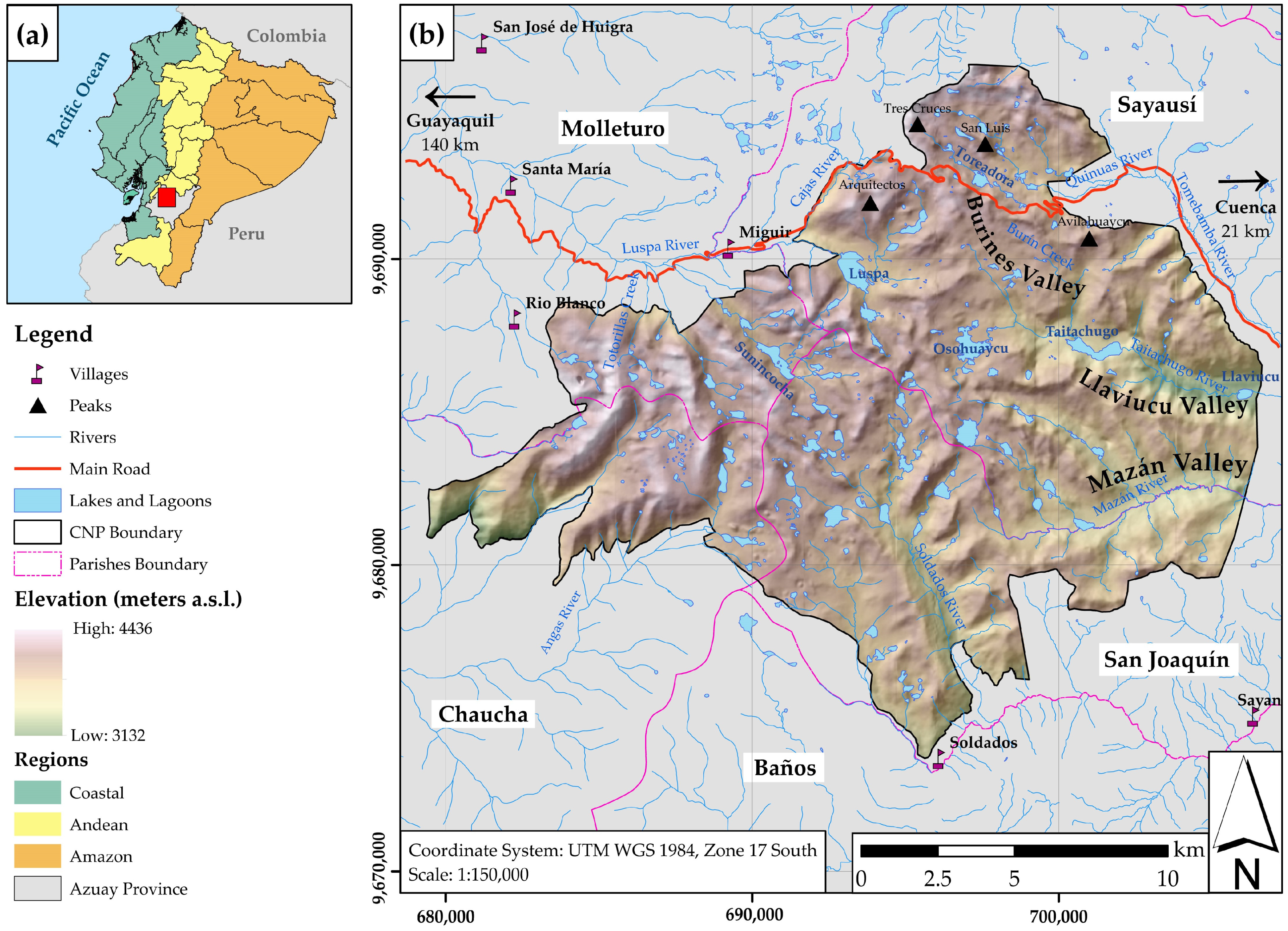
1.1. Study Area
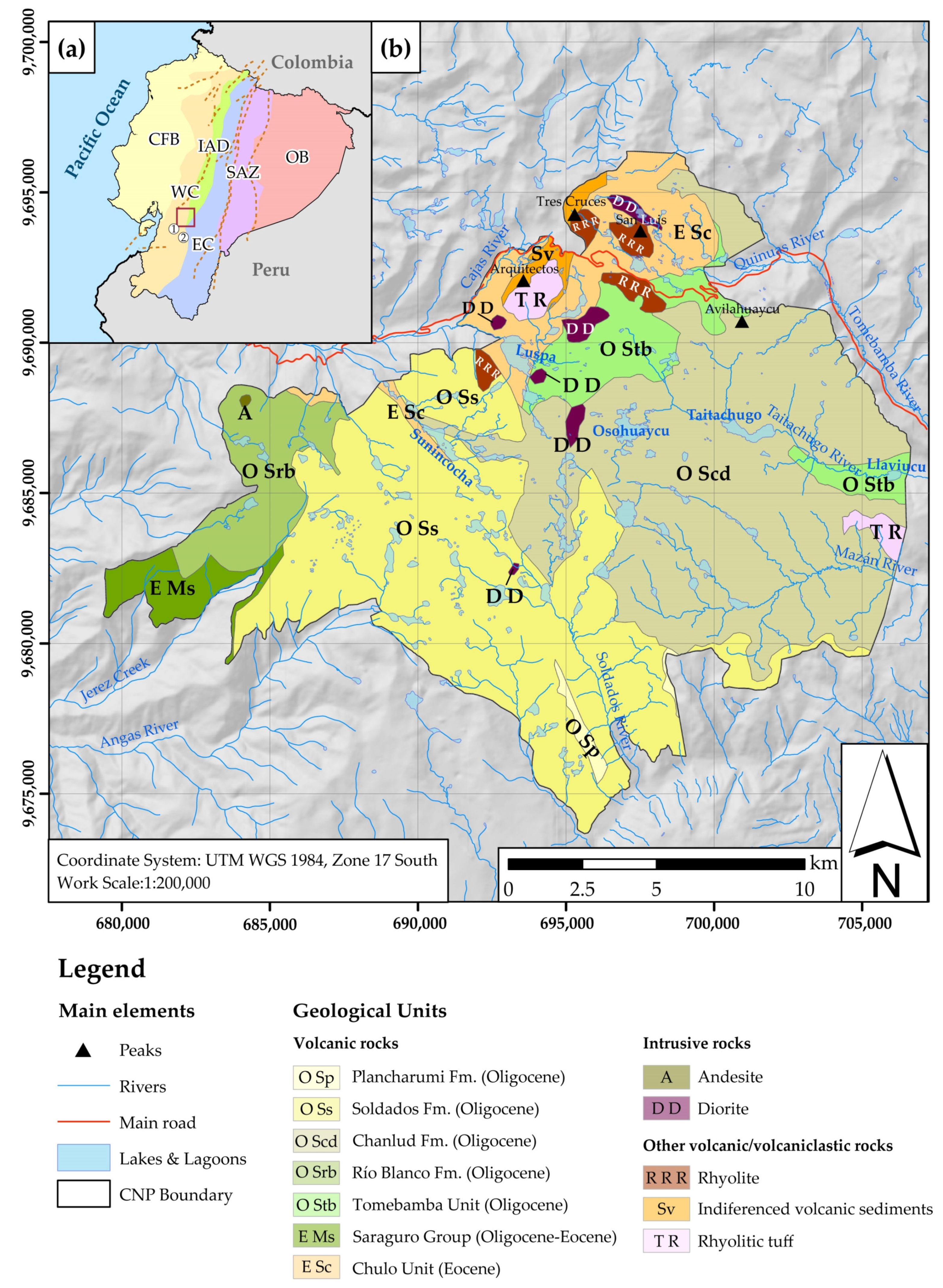
1.2. Geologic Framework
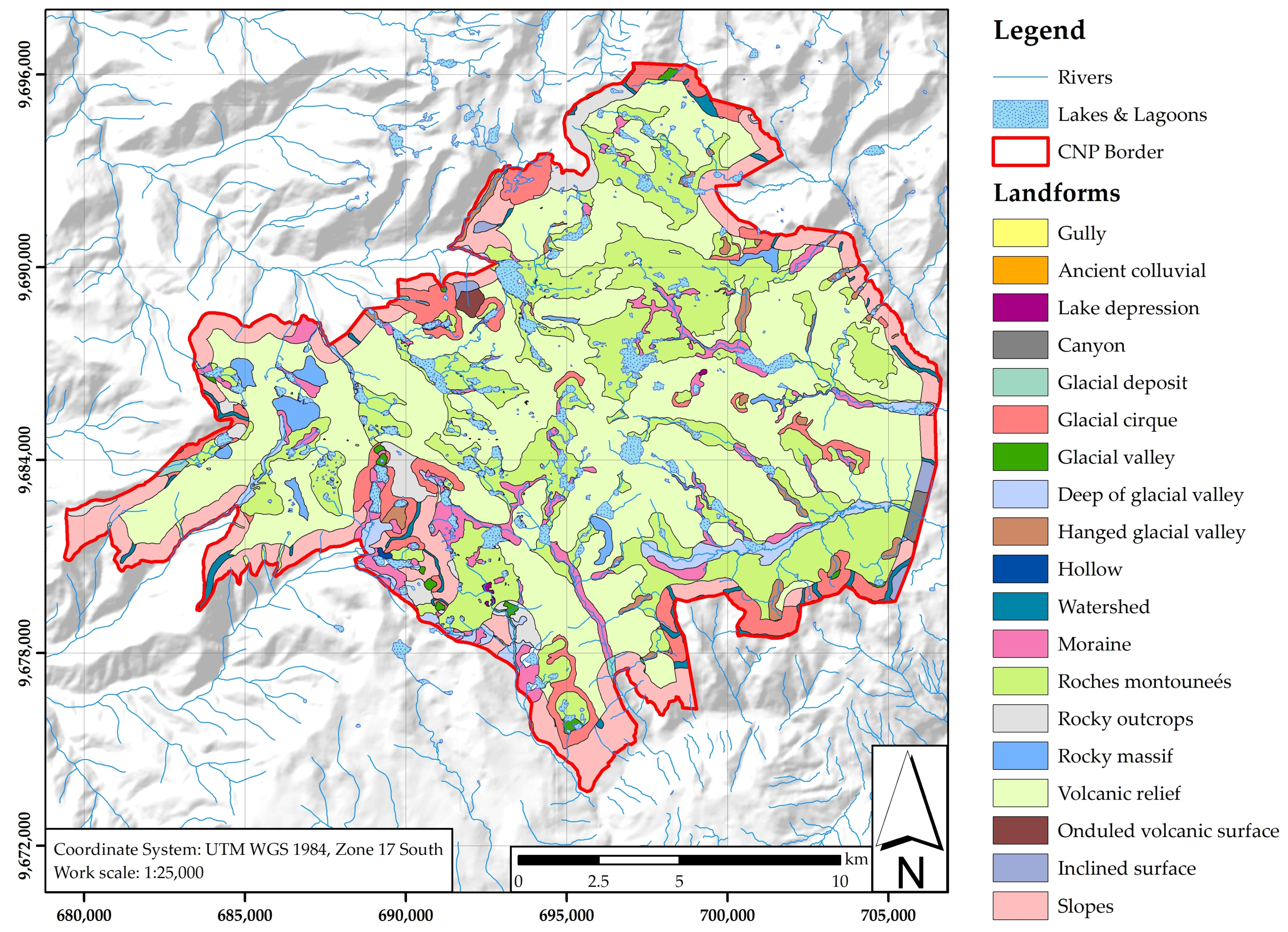
1.3. Geomorphological Framework
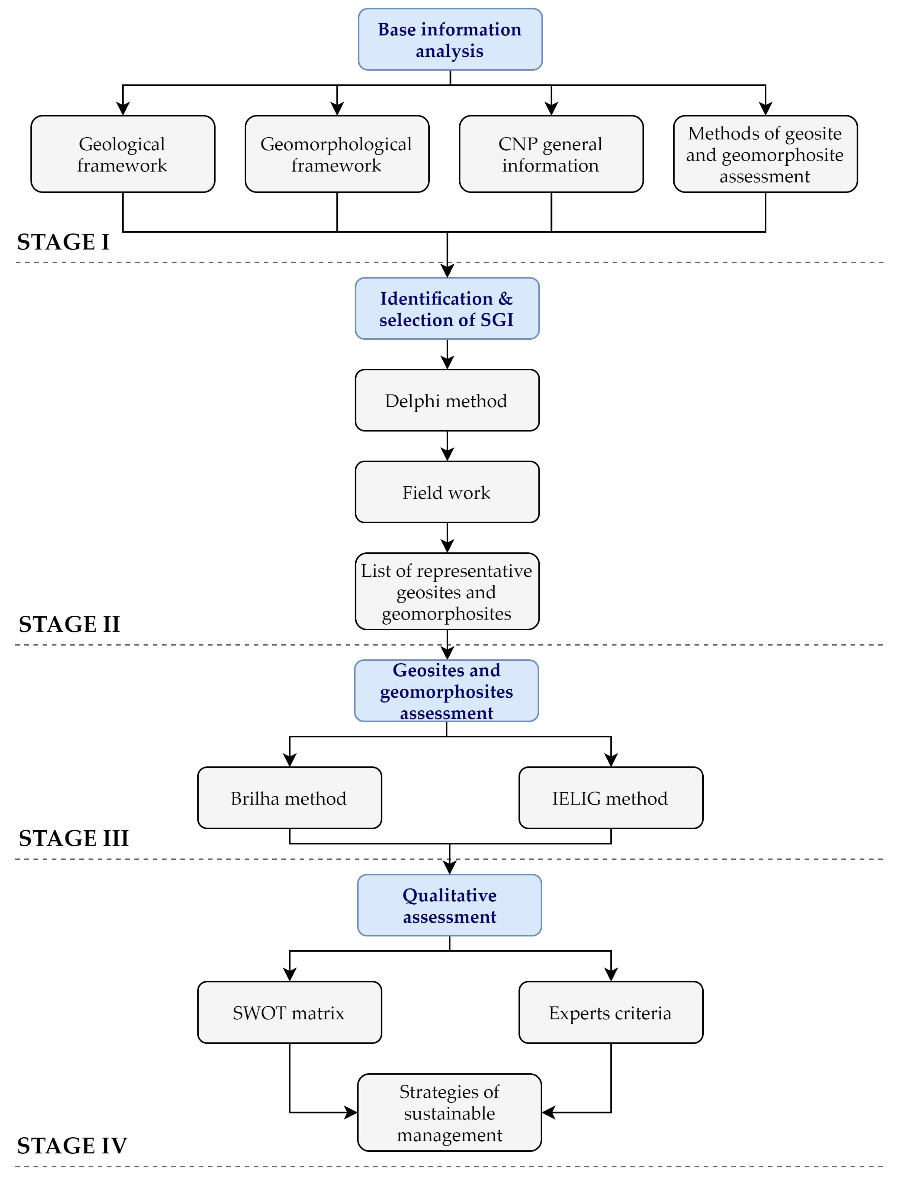
2. Materials and Methods
2.1. Stage I: Base Information Analysis of the Study Area
2.2. Stage II: Identification and Selection of Sites of Geological Interest
2.3. Stage III: Geosite and Geomorphosite Assessment
2.3.1. Brilha Method
2.3.2. IELIG Method
2.4. Stage IV: Qualitative Assessment
3. Results
3.1. Geosites and Geomorphosites of CNP
3.2. Geosite and Geomorphosite Assessment
3.2.1. Assessment by the Brilha Method
3.2.2. Assessment by the IELIG Method
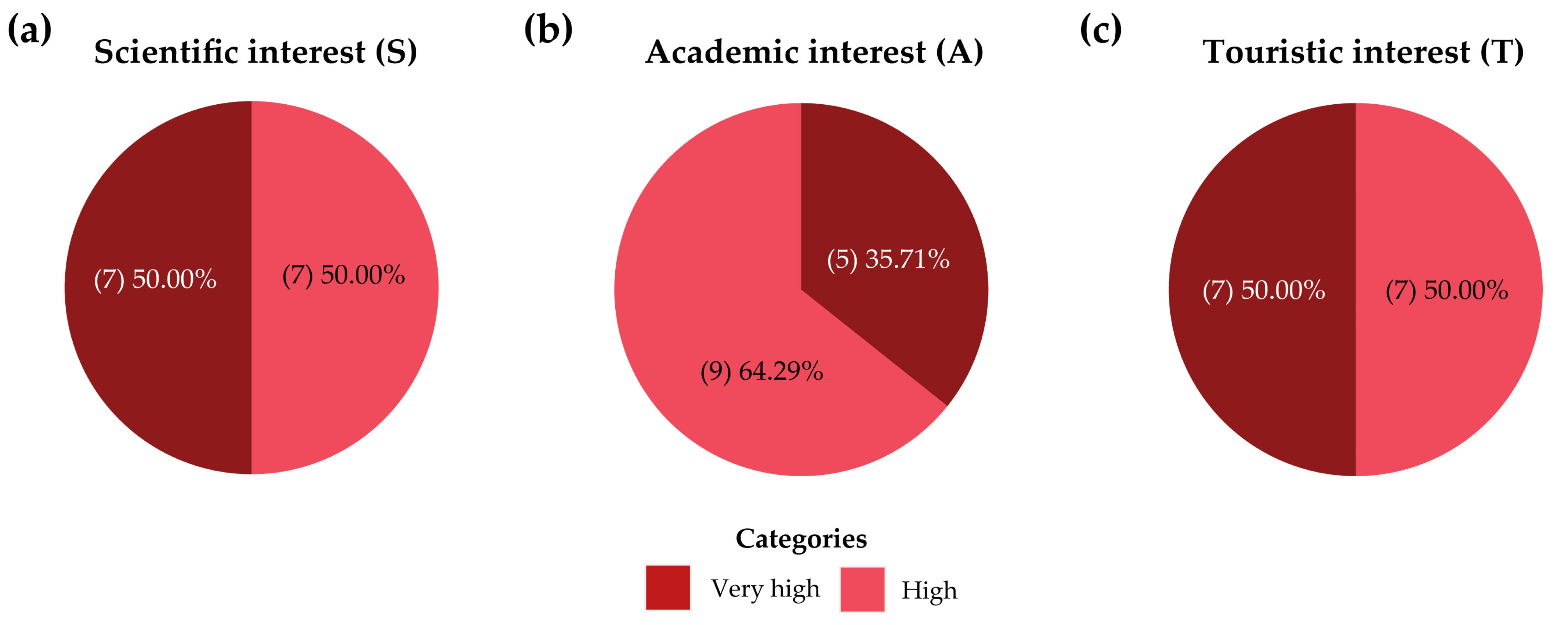
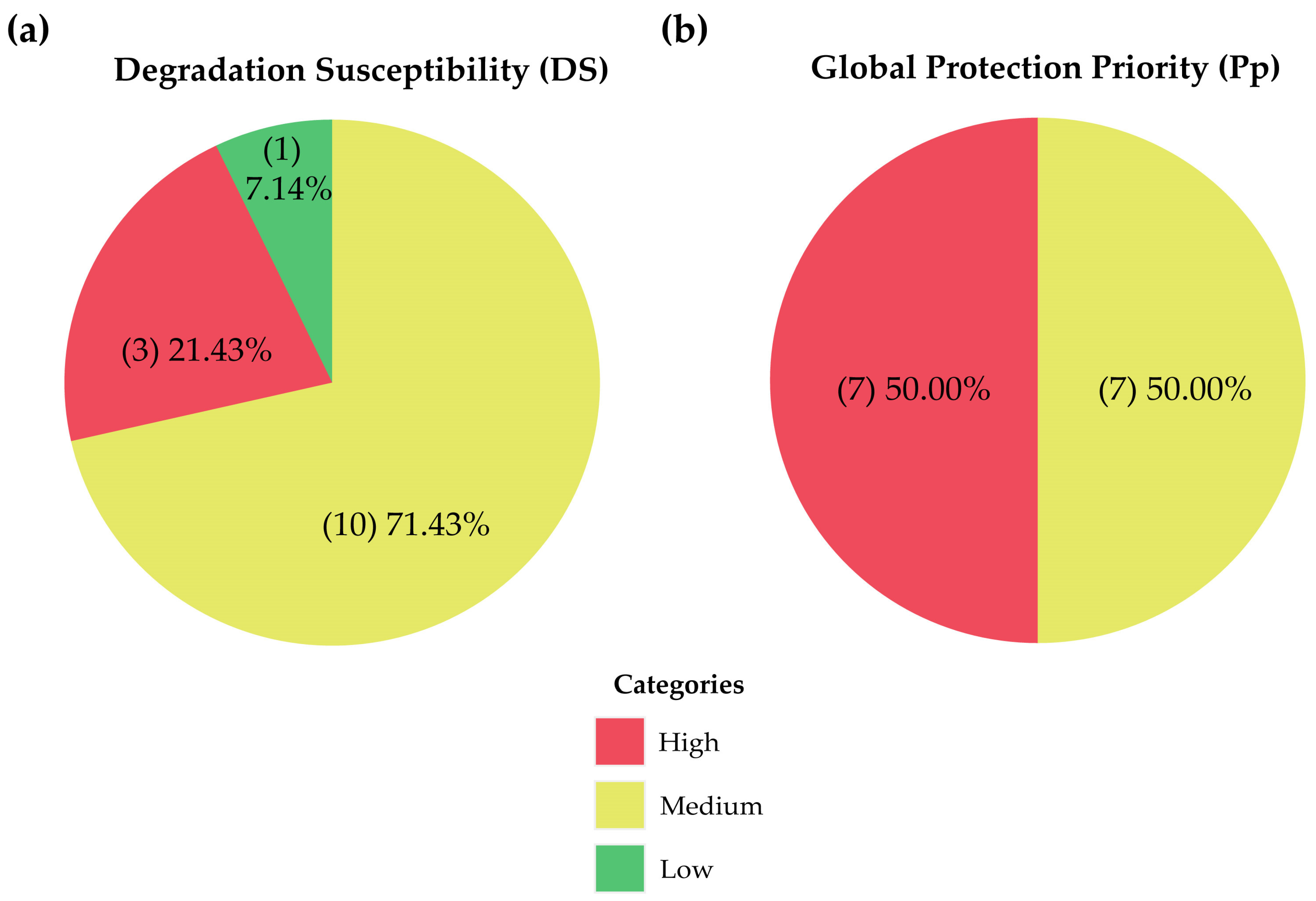
3.3. Qualitative Assessment
- Design an inventory and characterisation protocol for the park’s geosites, articulated with current natural heritage inventory programs (flora and fauna), that integrates all the stakeholders dedicated to the conservation of CNP;
- Creation and installation of geological and geomorphological interpretive panels. These panels must combine a real photograph of the geosites–geomorphosites with graphic schemes illustrating the geological process of interest. A good practice is the implementation of the ABC (abiotic, biotic and cultural) interpretive concept [88] in the CNP panel system;
- Development of panoramic view areas, signage, information panels and safety means (e.g., installation of safety railings) at specific points where geomorphosites can be better observed and continue with the construction of trails and other facilities for tourism in some geosites (e.g., Miguir meteorite);
- Propose pilot projects for the development of geotourism that integrate the values of cultural and natural interest present in the current tourist trails of the park with the geological value of the sites characterised in this study;
- Include geotourism guides and descriptions of the geological value in the information brochures and other informative material promoting geoheritage and geomorphological heritage education.
4. Discussion
5. Conclusions
Author Contributions
Funding
Institutional Review Board Statement
Informed Consent Statement
Data Availability Statement
Acknowledgments
Conflicts of Interest
References
- Serrano, E.; Ruiz-Flaño, P. Geodiversity: A theoretical and applied concept. Geogr. Helv. 2007, 62, 140–147. [Google Scholar] [CrossRef]
- ProGEO. Conserving Our Shared Geoheritage—A Protocol on Geoconservation Principles, Sustainable Site Use, Management, Fieldwork, Fossil and Mineral Collecting. 2011. Available online: https://www.sigeaweb.it/geoheritage/documents/progeo-protocol-definitions-20110915.pdf (accessed on 7 June 2021).
- De Wever, P.; Guiraud, M. Geoheritage and Museums. In Geoheritage; Reynard, E., Brilha, J., Eds.; Elsevier: Amsterdam, The Netherlands, 2018; pp. 129–145. [Google Scholar]
- Brilha, J. Geoheritage: Inventories and evaluation. In Geoheritage; Reynard, E., Brilha, J., Eds.; Elsevier: Amsterdam, The Netherlands, 2018; pp. 69–85. [Google Scholar]
- Gordon, J.E.; Barron, H.F.; Hansom, J.D.; Thomas, M.F. Engaging with geodiversity—Why it matters. Proc. Geol. Assoc. 2012, 123, 1–6. [Google Scholar] [CrossRef] [Green Version]
- Wimbledon, W.A.P.; Smith-Meyer, S. Geoheritage in Europe and Its Conservation; ProGEO: Oslo, Norway, 2012. [Google Scholar]
- Erikstad, L. Geoheritage and geodiversity management—the questions for tomorrow. Proc. Geol. Assoc. 2013, 124, 713–719. [Google Scholar] [CrossRef]
- Garavaglia, V.; Diolaiuti, G.; Smiraglia, C.; Pasquale, V.; Pelfini, M. Evaluating Tourist Perception of Environmental Changes as a Contribution to Managing Natural Resources in Glacierized Areas: A Case Study of the Forni Glacier (Stelvio National Park, Italian Alps). Environ. Manag. 2012, 50, 1125–1138. [Google Scholar] [CrossRef]
- Vukoičić, D.; Milosavljević, S.; Valjarević, A.; Nikolić, M.; Srećković-Batoćanin, D. The evaluation of geosites in the territory of National park “Kopaonik” (Serbia). Open Geosci. 2018, 10, 618–633. [Google Scholar] [CrossRef]
- Bucci, F.; Tavarnelli, E.; Novellino, R.; Palladino, G.; Guglielmi, P.; Laurita, S.; Prosser, G.; Bentivenga, M. The History of the Southern Apennines of Italy Preserved in the Geosites Along a Geological Itinerary in the High Agri Valley. Geoheritage 2019, 11, 1489–1508. [Google Scholar] [CrossRef]
- Ramsay, T. Fforest fawr geopark—A UNESCO global geopark distinguished by its geological, industrial and cultural heritage. Proc. Geol. Assoc. 2017, 128, 500–509. [Google Scholar] [CrossRef]
- Santangelo, N.; Romano, P.; Santo, A. Geo-itineraries in the Cilento Vallo di Diano Geopark: A Tool for Tourism Development in Southern Italy. Geoheritage 2015, 7, 319–335. [Google Scholar] [CrossRef]
- Keever, P.J.M.; Zouros, N. Geoparks: Celebrating Earth heritage, sustaining local communities. Episodes 2005, 28, 274–278. [Google Scholar] [CrossRef] [Green Version]
- ProGEO. Digne-Les-Bains Declaration-Declaration of the Rights of the Memory of the Earth; ProGEO: Digne, France, 1991. [Google Scholar]
- Bruno, D.E.; Crowley, B.E.; Gutak, J.M.; Moroni, A.; Nazarenko, O.V.; Oheim, K.B.; Ruban, D.A.; Tiess, G.; Zorina, S.O. Paleogeography as geological heritage: Developing geosite classification. Earth Sci. Rev. 2014, 138, 300–312. [Google Scholar] [CrossRef]
- Reynard, E. Geosite. In Encyclopedia of Geomorphology; Goudie, A., Ed.; Routledge: London, UK, 2014; Volume 1, ISBN 9780415863001. [Google Scholar]
- Ruban, D.A.; Kuo, I. Essentials of geological heritage site (geosite) management: A conceptual assessment of interests and conflicts. Nat. Nascosta 2010, 41, 16–31. [Google Scholar]
- Panizza, M. Geomorphosites: Concepts, methods and examples of geomorphological survey. Chinese Sci. Bull. 2001, 46, 4–5. [Google Scholar] [CrossRef]
- Reynard, E. Geomorphosites: Definitions and characteristics. In Geomorphosites; Verlag Dr. Friedrich Pfeil: München, Germany, 2009; pp. 9–20. ISBN 978-3-89937-094-2. [Google Scholar]
- Pescatore, E.; Bentivenga, M.; Giano, S.I.; Siervo, V. Geomorphosites: Versatile Tools in Geoheritage Cultural Dissemination. Geoheritage 2019, 11, 1583–1601. [Google Scholar] [CrossRef]
- Coratza, P.; De Waele, J. Geomorphosites and Natural Hazards: Teaching the Importance of Geomorphology in Society. Geoheritage 2012, 4, 195–203. [Google Scholar] [CrossRef]
- Quesada-Román, A.; Pérez-Umaña, D. Tropical Paleoglacial Geoheritage Inventory for Geotourism Management of Chirripó National Park, Costa Rica. Geoheritage 2020, 12, 58. [Google Scholar] [CrossRef]
- Jon, W.-S.; Ryang, D.-Z.; Ri, H.-Y. Natural Heritage Value of Mt. Kumgang and Global Comparative Analysis. Geoheritage 2020, 12, 32. [Google Scholar] [CrossRef]
- Tavera Escobar, M.A.; Estrada Sierra, N.; Errázuriz Henao, C.; Hermelin, M. Georutas o itinerarios geológicos: Un modelo de geoturismo en el Complejo Volcánico Glaciar Ruiz-Tolima, Cordillera Central de Colombia. Cuad. Geogr. Rev. Colomb. Geogr. 2017, 26, 219–240. [Google Scholar] [CrossRef]
- Perret, A.; Reynard, E. A method for selecting potential geosites. The case of glacial geosites in the Chablais area (French and Swiss Prealps). In Proceedings of the EGU General Assembly Conference Abstracts, Vienna, Austria, 27 April–2 May 2014; p. 12035. [Google Scholar]
- Vieira, G.; de Castro, E.; Gomes, H.; Loureiro, F.; Fernandes, M.; Patrocínio, F.; Firmino, G.; Forte, J. The Estrela Geopark—From Planation Surfaces to Glacial Erosion. In Landscapes and Landforms of Portugal; Springer: Cham, Switzerland, 2020; pp. 341–357. [Google Scholar]
- Pérez Alberti, A. El patrimonio glaciar y periglaciar del Geoparque Mundial UNESCO Montañas do Courel (Galicia). Cuatern. Y Geomorfol. 2021, 35, 79–98. [Google Scholar] [CrossRef]
- Mucivuna, V.C.; Reynard, E.; da Garcia, M.M. Geomorphosites Assessment Methods: Comparative Analysis and Typology. Geoheritage 2019, 11, 1799–1815. [Google Scholar] [CrossRef]
- Zafeiropoulos, G.; Drinia, H.; Antonarakou, A.; Zouros, N. From Geoheritage to Geoeducation, Geoethics and Geotourism: A Critical Evaluation of the Greek Region. Geosciences 2021, 11, 381. [Google Scholar] [CrossRef]
- Fassoulas, C.; Mouriki, D.; Dimitriou-Nikolakis, P.; Iliopoulos, G. Quantitative Assessment of Geotopes as an Effective Tool for Geoheritage Management. Geoheritage 2012, 4, 177–193. [Google Scholar] [CrossRef]
- Reynard, E.; Fontana, G.; Kozlik, L.; Scapozza, C. A method for assessing “scientific” and “additional values” of geomorphosites. Geogr. Helv. 2007, 62, 148–158. [Google Scholar] [CrossRef]
- Brilha, J. Inventory and Quantitative Assessment of Geosites and Geodiversity Sites: A Review. Geoheritage 2016, 8, 119–134. [Google Scholar] [CrossRef] [Green Version]
- Pereira, P.; Pereira, D.; Caetano Alves, M.I. Geomorphosite assessment in Montesinho Natural Park (Portugal). Geogr. Helv. 2007, 62, 159–168. [Google Scholar] [CrossRef] [Green Version]
- De Lima, F.F.; Brilha, J.B.; Salamuni, E. Inventorying Geological Heritage in Large Territories: A Methodological Proposal Applied to Brazil. Geoheritage 2010, 2, 91–99. [Google Scholar] [CrossRef] [Green Version]
- Kubalíková, L. Koncepce Geomorphosites v Kontextu Ochrany Neživé Přírody; Technická Univerzita v Liberci: Liberec, Czech Republic, 2012; ISBN 978-80-7372-932-5. [Google Scholar]
- Pralong, J.-P.; Reynard, E. A proposal for a classification of geomorphological sites depending on their tourist value. Ital. J. Quat. Sci. 2005, 18, 315–321. [Google Scholar]
- Pralong, J.-P. A method for assessing tourist potential and use of geomorphological sites. Géomorphol. Reli. Process. Environ. 2005, 11, 189–196. [Google Scholar] [CrossRef]
- Bruschi, V.M.; Cendrero, A. Geosite evaluation; can we measure intangible values? Quaternario 2005, 18, 293–306. [Google Scholar]
- Coratza, P.; Giusti, C. Methodological proposal for the assessment of the scientific quality of geomorphosites. Quaternario 2005, 18, 307–313. [Google Scholar]
- García-Cortés, A.; Carcavilla, L. Documento Metodológico Para la Elaboración del Inventario Español de Lugares de Interés Geológico (IELIG); Instituto Geolớgico y Minero de España (IGME): Madrid, Spain, 2013. [Google Scholar]
- Vujičić, M.D.; Vasiljević, D.A.; Marković, S.B.; Hose, T.A.; Lukić, T.; Hadžić, O.; Janićević, S. Preliminary geosite assessment model (GAM) and its application on Fruška gora mountain, potential geotourism destination of Serbia. Acta Geogr. Slov. 2011, 51, 361–376. [Google Scholar] [CrossRef]
- Comănescu, L.; Nedelea, A. Geomorphosites Assessments of the Glacial and Periglacial Landforms from Southern Carpathians. In Landform Dynamics and Evolution in Romania; Radoane, M., Vespremeanu-Stroe, A., Eds.; Springer: Cham, Switzerland, 2017; pp. 215–246. [Google Scholar]
- Ólafsdóttir, R.; Tverijonaite, E. Geotourism: A Systematic Literature Review. Geosciences 2018, 8, 234. [Google Scholar] [CrossRef] [Green Version]
- Herrera-Franco, G.; Montalván-Burbano, N.; Carrión-Mero, P.; Apolo-Masache, B.; Jaya-Montalvo, M. Research Trends in Geotourism: A Bibliometric Analysis Using the Scopus Database. Geosciences 2020, 10, 379. [Google Scholar] [CrossRef]
- Hose, T.A. Selling the story of Britain’s stone. Environ. Interpret. 1995, 10, 16–17. [Google Scholar]
- Convention on Biological Diversity. Available online: https://www.cbd.int/countries/profile/?country=ec (accessed on 23 August 2021).
- Carrión-Mero, P.C.; Morante-Carballo, F.E.; Herrera-Franco, G.A.; Maldonado-Zamora, A.; Paz-Salas, N. The context of Ecuador’s world heritage, for sustainable development strategies. Int. J. Des. Nat. Ecodynamics 2020, 15, 39–46. [Google Scholar] [CrossRef]
- Rieckmann, M.; Adomßent, M.; Härdtle, W.; Aguirre, P. Sustainable Development and Conservation of Biodiversity Hotspots in Latin America: The Case of Ecuador. In Biodiversity Hotspots; Zachos, F., Habel, J., Eds.; Springer: Berlin/Heidelberg, Germany, 2011; pp. 435–452. [Google Scholar]
- Sánchez-Cortez, J.L. Conservation of geoheritage in Ecuador: Situation and perspectives. Int. J. Geoheritage Park. 2019, 7, 91–101. [Google Scholar] [CrossRef]
- Ministerio de Ambiente y Agua-República del Ecuador Sistema Nacional de Áreas Protegidas del Ecuador. Available online: http://areasprotegidas.ambiente.gob.ec/es (accessed on 31 October 2021).
- United Nations Educational, Scientific and Cultural Organization (UNESCO). Macizo del Cajas Biosphere Reserve, Ecuador. Available online: https://en.unesco.org/biosphere/lac/macizo-del-cajas (accessed on 23 August 2021).
- SISR Parque Nacional Cajas | Servicio de Información sobre Sitios Ramsar. Available online: https://rsis.ramsar.org/es/ris/1203?language=es (accessed on 23 August 2021).
- Navarrete, E. Huellas de un “frío pasado”. Patrimonio Geológico del Parque Nacional “El Cajas.” In El Patrimonio Geominero en el Contexto de la Ordenación Territorial; Mistral: Guayaquil, Ecuador, 2005; pp. 181–197. [Google Scholar]
- Berrezueta, E.; Sánchez-Cortez, J.L.; Aguilar-Aguilar, M. Inventory and Characterization of Geosites in Ecuador: A Review. Geoheritage 2021, 13, 93. [Google Scholar] [CrossRef]
- De la Vega, G. Comentarios Reales de los Incas; Biblioteca de Autores Españoles: Madrid, Spain, 1609; ISBN 9681648927. [Google Scholar]
- ETAPA E.P.; GAD Municipal Cuenca; MAE. Plan de Manejo del Parque Nacional El Cajas; INSIGMA: Cuenca, Ecuador, 2018. [Google Scholar]
- ETAPA E.P.; MAE. Expediente para la Inscripción del Parque Nacional El Cajas y los Tramos Transversales del Qhapaq Ñan en la Lista de Patrimonio Mundial de la UNESCO; UNESCO: Cuenca, Ecuador, 2007. [Google Scholar]
- Ministerio de Ambiente Agua y Transición Ecológica-República del Ecuador Parque Nacional El Cajas—Ministerio del Ambiente, Agua y Transición Ecológica. Available online: https://www.ambiente.gob.ec/parque-nacional-cajas/ (accessed on 11 November 2021).
- Báez, S.; Ospina, P.; Ramón, G. Una Breve Historia del Espacio Ecuatoriano; CAMAREN: Instituto de Estudios Ecuatorianos (IEE): Quito, Ecuador, 2004. [Google Scholar]
- Buytaert, W.; Sevink, J.; De Leeuw, B.; Deckers, J. Clay mineralogy of the soils in the south Ecuadorian páramo region. Geoderma 2005, 127, 114–129. [Google Scholar] [CrossRef]
- Buytaert, W.; Poyck, S.; Iñiguez, V.; De Bièvre, B. Hill slope flow in organic soils, a case study from the Ecuadorian páramo ecosystem. In Geophysical Research Abstracts; European Geosciences Union: Munich, Germany, 2006. [Google Scholar]
- Dunkley, P.; Gaibor, A. Mapa Geológico de la Cordillera Occidental del Ecuador Entre 2°–3° S, Escala: 1:200,000; Instituto de Investigación Geológico y Energético (IIGE): Quito, Ecuador, 1997. [Google Scholar]
- Eguez, A.; Alvarado, A.Y.H.; Machette, M.N.; Costa, C.; Dart, R.L. Map of Quaternary Faults and Folds of Ecuador and Its Offshore Regions. Available online: https://pubs.usgs.gov/of/2003/ofr-03-289/ (accessed on 23 August 2021).
- Beate, B.; Monzier, M.; Spikings, R.; Cotten, J.; Silva, J.; Bourdon, E.; Eissen, J.-P. Mio–Pliocene adakite generation related to flat subduction in southern Ecuador: The Quimsacocha volcanic center. Earth Planet. Sci. Lett. 2001, 192, 561–570. [Google Scholar] [CrossRef]
- Schütte, P.; Chiaradia, M.; Barra, F.; Villagómez, D.; Beate, B. Metallogenic features of Miocene porphyry Cu and porphyry-related mineral deposits in Ecuador revealed by Re-Os, 40Ar/39Ar, and U-Pb geochronology. Miner. Depos. 2012, 47, 383–410. [Google Scholar] [CrossRef] [Green Version]
- Hall, M.L.; Calle, J. Geochronological control for the main tectonic-magmatic events of Ecuador. Earth Sci. Rev. 1982, 18, 215–239. [Google Scholar] [CrossRef]
- Coltorti, M.; Ollier, C.D. Geomorphic and tectonic evolution of the Ecuadorian Andes. Geomorphology 2000, 32, 1–19. [Google Scholar] [CrossRef]
- Barberi, F.; Coltelli, M.; Ferrara, G.; Innocenti, F.; Navarro, J.M.; Santacroce, R. Plio-Quaternary volcanism in Ecuador. Geol. Mag. 1988, 125, 1–14. [Google Scholar] [CrossRef]
- Aspden, J.A.; Litherland, M. The geology and Mesozoic collisional history of the Cordillera Real, Ecuador. Tectonophysics 1992, 205, 187–204. [Google Scholar] [CrossRef]
- BGS-CODIGEM. Mapa Geologico de la República Del Ecuador. Escala, 1:1000000; Instituto de Investigación Geológico y Energético (IIGE): Quito, Ecuador, 1983. [Google Scholar]
- Cediel, F.; Shaw, R.; Cáceres, C. Tectonic assembly of the northern Andean block. Assoc. Pet. Geol. Mem. 2003, 79, 815–848. [Google Scholar]
- Jackson, L.J.; Horton, B.K.; Vallejo, C. Detrital zircon U-Pb geochronology of modern Andean rivers in Ecuador: Fingerprinting tectonic provinces and assessing downstream propagation of provenance signals. Geosphere 2019, 15, 1943–1957. [Google Scholar] [CrossRef] [Green Version]
- Rodbell, D.T.; Bagnato, S.; Nebolini, J.C.; Seltzer, G.O.; Abbott, M.B. A Late Glacial–Holocene Tephrochronology for Glacial Lakes in Southern Ecuador. Quat. Res. 2002, 57, 343–354. [Google Scholar] [CrossRef]
- Rodbell Donald, T.; Nebolini Jeffrey, C.; Seltzer Geoffrey, O.; Hansen Barbara, C.S.; Abbott Mark, B. Tephrochronology, sedimentology, and palynology of late glacial-Holocene lake sediment cores from southern Ecuador. Abstr. Programs-Geol. Soc. Am. 1996, 28, 471. [Google Scholar]
- Hansen, B.C.; Rodbell, D.; Seltzer, G.; León, B.; Young, K.; Abbott, M. Late-glacial and Holocene vegetational history from two sites in the western Cordillera of southwestern Ecuador. Palaeogeogr. Palaeoclimatol. Palaeoecol. 2003, 194, 79–108. [Google Scholar] [CrossRef]
- Carrasco, M. Estudio Limnológico y de Macroinvertebrados Bentónico en la Zona de Surocucho; Universidad del Azuay: Cuenca, Ecuador, 1996. [Google Scholar]
- Mosquera, P.V.; Hampel, H.; Vázquez, R.F.; Alonso, M.; Catalan, J. Abundance and morphometry changes across the high-mountain lake-size gradient in the tropical Andes of Southern Ecuador. Water Resour. Res. 2017, 53, 7269–7280. [Google Scholar] [CrossRef] [Green Version]
- MAG-IEE-SENPLADES. Mosaico homologado a nivel nacional, 1:25,000. 2009-2015 Geomorfología (Formas del Relieve). Available online: http://geoportal.agricultura.gob.ec/ (accessed on 7 June 2021).
- McKenna, H.P. The Delphi technique: A worthwhile research approach for nursing? J. Adv. Nurs. 1994, 19, 1221–1225. [Google Scholar] [CrossRef]
- Hasson, F.; Keeney, S. Enhancing rigour in the Delphi technique research. Technol. Forecast. Soc. Chang. 2011, 78, 1695–1704. [Google Scholar] [CrossRef]
- Mucivuna, V.C.; Motta Garcia, M.d.G.; Reynard, E. Comparing quantitative methods on the evaluation of scientific value in geosites: Analysis from the Itatiaia National Park, Brazil. Geomorphology 2022, 396, 107988. [Google Scholar] [CrossRef]
- Garcia, M.d.G.M.; Brilha, J.; de Lima, F.F.; Vargas, J.C.; Pérez-Aguilar, A.; Alves, A.; Campanha, G.A.d.C.; Duleba, W.; Faleiros, F.M.; Fernandes, L.A.; et al. The Inventory of Geological Heritage of the State of São Paulo, Brazil: Methodological Basis, Results and Perspectives. Geoheritage 2018, 10, 239–258. [Google Scholar] [CrossRef] [Green Version]
- Mehdioui, S.; El Hadi, H.; Tahiri, A.; Brilha, J.; El Haibi, H.; Tahiri, M. Inventory and Quantitative Assessment of Geosites in Rabat-Tiflet Region (North Western Morocco): Preliminary Study to Evaluate the Potential of the Area to Become a Geopark. Geoheritage 2020, 12, 35. [Google Scholar] [CrossRef]
- Santos, D.S.; Reynard, E.; Mansur, K.L.; Seoane, J.C.S. The Specificities of Geomorphosites and Their Influence on Assessment Procedures: A Methodological Comparison. Geoheritage 2019, 11, 2045–2064. [Google Scholar] [CrossRef]
- Chrobak, A.; Witkowski, K.; Szmańda, J. Assessment of the Educational Values of Geomorphosites Based on the Expert Method, Case Study: The Białka and Skawa Rivers, the Polish Carpathians. Quaest. Geogr. 2020, 39, 45–57. [Google Scholar] [CrossRef]
- Dyson, R.G. Strategic development and SWOT analysis at the University of Warwick. Eur. J. Oper. Res. 2004, 152, 631–640. [Google Scholar] [CrossRef]
- Toulkeridis, T.; Echegaray-Aveiga, R.C.; Martinez-Maldonado, K.P. Shock metamorphism in volcanic rock due to the impact of the Miguir-Cajas meteorite in 1995 and its importance for Ecuador. Geoj. Tour. Geosites 2021, 35, 315–321. [Google Scholar] [CrossRef]
- Pásková, M.; Zelenka, J.; Ogasawara, T.; Zavala, B.; Astete, I. The ABC Concept—Value Added to the Earth Heritage Interpretation? Geoheritage 2021, 13, 38. [Google Scholar] [CrossRef]
- Ilieş, D.C.; Dehoorne, O.; Ilieş, A. Some examples of natural hazards affecting geosites and tourist activities. Geoj. Tour. Geosites 2011, 7, 33–38. [Google Scholar]
- Margiotta, S.; Negri, S.; Parise, M.; Quarta, T.A.M. Karst geosites at risk of collapse: The sinkholes at Nociglia (Apulia, SE Italy). Environ. Earth Sci. 2016, 75, 8. [Google Scholar] [CrossRef]
- Costa-Casais, M.; Caetano Alves, M.I. Geological Heritage at Risk in NW Spain. Quaternary Deposits and Landforms of “Southern Coast” (Baiona-A Garda). Geoheritage 2013, 5, 227–248. [Google Scholar] [CrossRef]
- Fränkl, L.A. A 20th Century Pollution History Reconstruction Using Lake Sediments from Cajas National Park, South Central Ecuador. Master’s Thesis, University of Bern, Bern, Switzerland, 2016. [Google Scholar]
- Schneider, T.; Musa Bandowe, B.A.; Bigalke, M.; Mestrot, A.; Hampel, H.; Mosquera, P.V.; Fränkl, L.; Wienhues, G.; Vogel, H.; Tylmann, W.; et al. 250-year records of mercury and trace element deposition in two lakes from Cajas National Park, SW Ecuadorian Andes. Environ. Sci. Pollut. Res. 2021, 28, 16227–16243. [Google Scholar] [CrossRef] [PubMed]
- Gill, J.C. Geology and the Sustainable Development Goals. Episodes 2017, 40, 70–76. [Google Scholar] [CrossRef]
- Carrión-Mero, P.; Borja-Bernal, C.; Herrera-Franco, G.; Morante-Carballo, F.; Jaya-Montalvo, M.; Maldonado-Zamora, A.; Paz-Salas, N.; Berrezueta, E. Geosites and Geotourism in the Local Development of Communities of the Andes Mountains. A Case Study. Sustainability 2021, 13, 4624. [Google Scholar] [CrossRef]
- Carrión-Mero, P.; Ayala-Granda, A.; Serrano-Ayala, S.; Morante-Carballo, F.; Aguilar-Aguilar, M.; Gurumendi-Noriega, M.; Paz-Salas, N.; Herrera-Franco, G.; Berrezueta, E. Assessment of Geomorphosites for Geotourism in the Northern Part of the “Ruta Escondida” (Quito, Ecuador). Sustainability 2020, 12, 8468. [Google Scholar] [CrossRef]
- Ayala Granda, A.J.; Carrión Mero, P.C.; Gurumendi Noriega, M.; Herrera Franco, G.; Morante Carballo, F.; Paz Salas, N.A. Registro y valoración de geomorfositios de la zona sur de la Ruta Escondida, como alternativa de fomento a la geoconservación del paisaje en la región Caranqui-Ecuador. In Engineering, Integration, And Alliances for A Sustainable Development” “Hemispheric Cooperation for Competitiveness and Prosperity on A Knowledge-Based Economy, Proceedings of the 18th LACCEI International Multi-Conference for Engineering, Education, and Technology, Virtual, 27–31 July 2020; Latin American and Caribbean Consortium of Engineering Institutions: Buenos Aires, Argentina, 2020. [Google Scholar]
- Cruz, R.; Martínez-Graña, A.; Goy, J.L.; Nogueira, N. Analysis of the Geological Heritage and Geodiversity Index of Two Mountainous Areas in Spain: Béjar and El Barco Massifs. Geoheritage 2021, 13, 62. [Google Scholar] [CrossRef]
- Fuertes-Gutiérrez, I.; Fernández-Martínez, E. Mapping Geosites for Geoheritage Management: A Methodological Proposal for the Regional Park of Picos de Europa (León, Spain). Environ. Manag. 2012, 50, 789–806. [Google Scholar] [CrossRef]
- Reynard, E.; Perret, A.; Bussard, J.; Grangier, L.; Martin, S. Integrated Approach for the Inventory and Management of Geomorphological Heritage at the Regional Scale. Geoheritage 2016, 8, 43–60. [Google Scholar] [CrossRef]
- Sellier, D. A Deductive Method for the Selection of Geomorphosites: Application to Mont Ventoux (Provence, France). Geoheritage 2016, 8, 15–29. [Google Scholar] [CrossRef]
- Kubalíková, L.; Kirchner, K. Geosite and Geomorphosite Assessment as a Tool for Geoconservation and Geotourism Purposes: A Case Study from Vizovická vrchovina Highland (Eastern Part of the Czech Republic). Geoheritage 2016, 8, 5–14. [Google Scholar] [CrossRef]
- Santos, D.S.; Mansur, K.L.; Seoane, J.C.S.; Mucivuna, V.C.; Reynard, E. Methodological Proposal for the Inventory and Assessment of Geomorphosites: An Integrated Approach focused on Territorial Management and Geoconservation. Environ. Manag. 2020, 66, 476–497. [Google Scholar] [CrossRef] [PubMed]
- Štrba, L.; Rybár, P.; Baláž, B.; Molokáč, M.; Hvizdák, L.; Kršák, B.; Lukáč, M.; Muchová, L.; Tometzová, D.; Ferenčíková, J. Geosite assessments: Comparison of methods and results. Curr. Issues Tour. 2015, 18, 496–510. [Google Scholar] [CrossRef]
- ASGMI Bases para el desarrollo común del Patrimonio Geológico en los Servicios Geológicos de Iberoamérica. Available online: https://asgmi.org/wp-content/uploads/2018/10/Bases-Metodologicas-Patrimonio-Geologico.pdf (accessed on 21 February 2022).
- Zouros, N.C. Geomorphosite assessment and management in protected areas of Greece Case study of the Lesvos island—Coastal geomorphosites. Geogr. Helv. 2007, 62, 169–180. [Google Scholar] [CrossRef]
- Herrera-Franco, G.; Montalván-Burbano, N.; Carrión-Mero, P.; Jaya-Montalvo, M.; Gurumendi-Noriega, M. Worldwide Research on Geoparks through Bibliometric Analysis. Sustainability 2021, 13, 1175. [Google Scholar] [CrossRef]


| Criteria | Values | |||||||
|---|---|---|---|---|---|---|---|---|
| Scientific (S) | Educational Potential (UEP) | Potential Tourism Use (PTU) | Degradation Risk (DR) | |||||
| R 1 | W 2 | R 1 | W 2 | R 1 | W 2 | R 1 | W 2 | |
| Representativeness | 1–4 | 30 | 1–4 | 0 | 1–4 | 0 | 1–4 | 0 |
| Key locality | 20 | 0 | 0 | 0 | ||||
| Scientific knowledge | 5 | 0 | 0 | 0 | ||||
| Integrity | 15 | 0 | 0 | 0 | ||||
| Geological diversity | 5 | 10 | 0 | 0 | ||||
| Rarity | 15 | 0 | 0 | 0 | ||||
| Use limitations | 10 | 5 | 5 | 0 | ||||
| Vulnerability | 0 | 10 | 10 | 0 | ||||
| Accessibility | 0 | 10 | 10 | 15 | ||||
| Safety | 0 | 10 | 10 | 0 | ||||
| Logistics | 0 | 5 | 5 | 0 | ||||
| Density of population | 0 | 5 | 5 | 10 | ||||
| Association with other values | 0 | 5 | 5 | 0 | ||||
| Scenery | 0 | 5 | 15 | 0 | ||||
| Uniqueness | 0 | 5 | 10 | 0 | ||||
| Observation conditions | 0 | 10 | 5 | 0 | ||||
| Didactic potential | 0 | 20 | 0 | 0 | ||||
| Interpretative potential | 0 | 0 | 10 | 0 | ||||
| Economic level | 0 | 0 | 5 | 0 | ||||
| The proximity of recreational areas | 0 | 0 | 5 | 0 | ||||
| Deterioration of geological elements | 0 | 0 | 0 | 35 | ||||
| Proximity to areas/activities with potential to cause degradation | 0 | 0 | 0 | 20 | ||||
| Legal protection | 0 | 0 | 0 | 20 | ||||
| Total | - | 100 | - | 100 | - | 100 | - | 100 |
| Total (DR) | Degree of Degradation |
|---|---|
| <200 | Low |
| 201–300 | Moderate |
| 301–400 | High |
| Parameters | Score Range | Value (Weight) | ||
|---|---|---|---|---|
| Scientific (S) | Academic (A) | Touristic (T) | ||
| Representativeness | 0 to 4 | 30 | 5 | - |
| Standard of reference site | 10 | 5 | - | |
| Knowledge of the site | 15 | - | - | |
| State of conservation | 10 | 5 | - | |
| Conditions of observation | 10 | 5 | 5 | |
| Scarcity, rarity | 15 | 5 | - | |
| Geological diversity | 10 | 10 | - | |
| Educational values | - | 20 | - | |
| Logistics infrastructure | - | 15 | 5 | |
| Population density | - | 5 | 5 | |
| Accessibility | - | 15 | 10 | |
| Size of site | - | - | 15 | |
| Association with other natural elements | - | 5 | 5 | |
| Beauty | - | 5 | 20 | |
| Informative value | - | - | 15 | |
| Possibility of recreational/leisure activities | - | - | 5 | |
| Proximity to other places | - | - | 5 | |
| Socio-economic situation | - | - | 10 | |
| Total (weight) | 100 | 100 | 100 | |
| Parameter | Fragility (F) | Vulnerability (V) | ||
|---|---|---|---|---|
| Score | Weight | Score | Weight | |
| Geosite size | 0 to 4 | 40 | 0 to 4 | - |
| Vulnerability to looting | 30 | - | ||
| Natural hazards | 30 | - | ||
| Proximity of infrastructure | - | 20 | ||
| Mining exploitation interest | - | 15 | ||
| Protected area designation | - | 15 | ||
| Indirect protection | - | 15 | ||
| Accessibility | - | 15 | ||
| Ownership status | - | 10 | ||
| Population density | - | 5 | ||
| Proximity of recreational areas | - | 5 | ||
| Total (weight) | 100 | 100 | ||
| Protection Priority | Equation |
|---|---|
| Scientific Priority (S-Pp) | |
| Academic Priority (A-Pp) | |
| Tourist/recreational priority (T-Pp) | , |
| Protection Priority (Pp) |
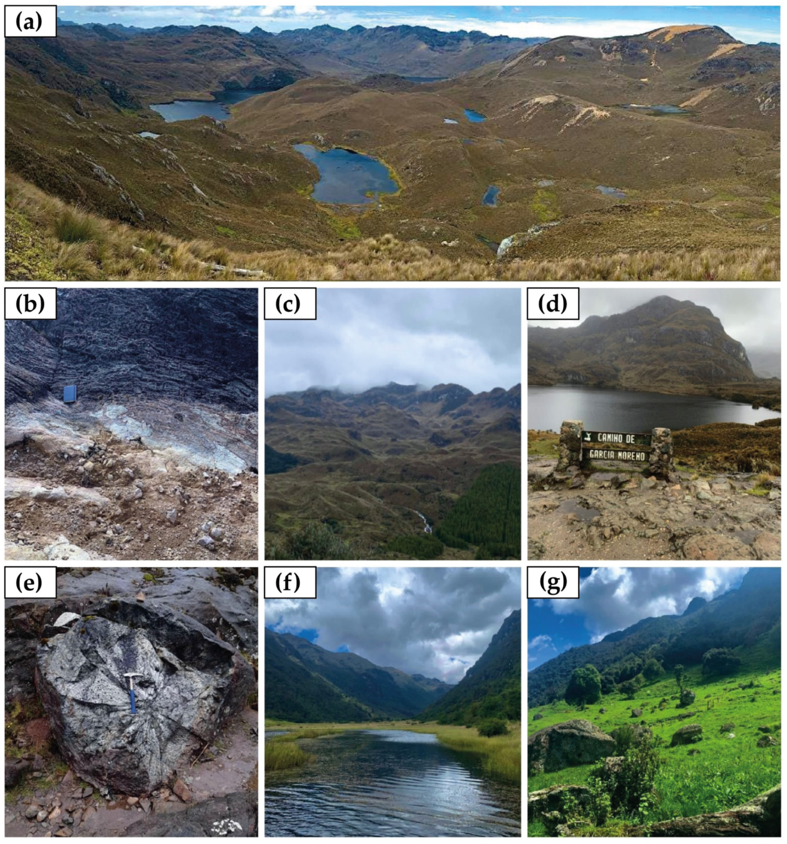
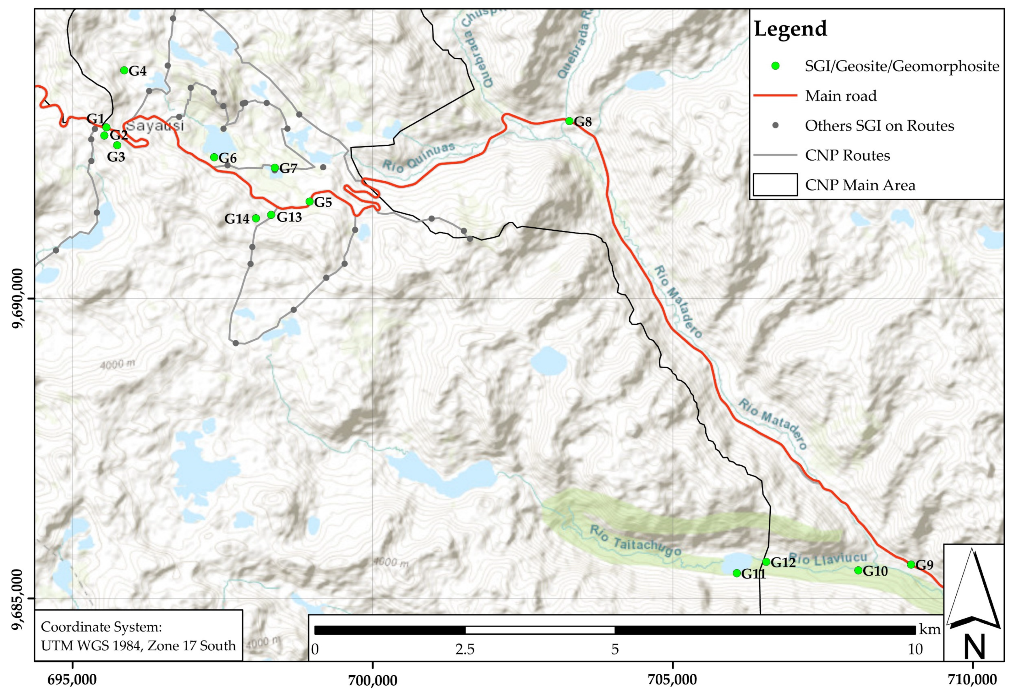
| No. | Name | Type of Site | Type of Primary Geological Interest | Type of Secondary Geological Interest | Main Features |
|---|---|---|---|---|---|
| G1 | Tres Cruces peak | Viewpoint | Geomorphological | Hydrological, glacial | (695563 E; 9692860 N) It presents glacial valley views as well as rocky sub-vertical outcrops and highlights the highest elevations in the western part of the geosite, constituting the watershed between the Pacific and Atlantic hydrographic basins. Due to the wind currents crossing from both systems, there are landforms by wind erosion, such as the “Cerro Amarillo”. The erosion phenomena exposed peak of this tuff hill has a yellow colour that gives it its name. The site has an additional cultural/historical value due to the presence of “apachetas” (stone mounds that mark milestones along the route and are related to religious offerings). |
| G2 | Larga and Negra lakes | Viewpoint | Glacial | Hydrological, geomorphological | (695528 E; 9692725 N) The geosite shows late Pleistocene glacial modelling, such as glacial cirques, hanging valleys, ridges and several lakes. The staggered geomorphological arrangement of the lakes (paternoster lake) represents the erosive action of glacial advance and retreat that characterised the place. The most representative lakes are Larga lake (24 ha.) and Negra lake (2.5 ha.). In addition, there are several rocky outcrops, the product of natural erosion of the highest parts of the elevation where they are located. Due to the proximity of the lakes, the space constitutes a point of high biological diversity. |
| G3 | Rocky outcrop Larga and Negra lakes | Point | Lithological | Hydrological, geomorphological, glacial | (695743 E; 9692562 N) It constitutes a vertical rocky outcrop on an arête that separates two valleys; one houses the Larga and Negra (West) lakes. According to Dunkley and Gaibor [62], the area is within the Chulo unit (Eocene), composed of sequences of lithologies of volcanic origin, such as rhyolitic tuffs and breccias. |
| G4 | Volcanic flows | Point | Lithological | Glacial, geomorphological, hydrological | (695860 E; 9693813 N) It is in the highest areas (4102 m.a.s.l.) of CNP. An outcrop is presented, showing a volcanic flow of andesitic tuffs. In the surroundings, there are rocks with a marked andesitic composition. In addition, there are panoramic views of lakes of glacial origin (e.g., Palcacocha), hanging valleys and roches moutonnées. |
| G5 | Drumlins camp | Viewpoint | Glacial | Hydrological, geomorphological, landscape | (698949 E; 9691621 N) The geosite located at the foot of the main road offers a panoramic view of an extensive field of asymmetric mounds of drumlins-type landforms. In addition, there are paternoster type lakes and fluvial slopes to the west. Finally, at the bottom of the valley there are examples of roches moutonnées. |
| G6 | Toreadora lake | Point | Glacial | Hydrological, erosional | (697359 E; 9692361 N) It is in the central part of the main tourist attractions of the park, consisting of a 19-hectare lake of glacial origin. You can see the peaks of Cerro San Luis (4295 m.a.s.l.), one of the highest elevations in CNP. The area has a natural interest due to the present examples of the endemic flora and fauna of the Andean Paramo. In addition, it presents a recognised regional historical value due to the García Moreno trail, one of the first modern transport routes between the Coastal and Andean regions. |
| G7 | Miguir meteorite | Point | Lithological | Hydrological, geomorphological | (698370 E; 9692187 N) The geosite is an example of impact metamorphism; it constitutes a block of andesite metamorphosed by the impact caused by a meteorite fragment a few centimetres in size, which occurred in 1995 [87]. The block physically presents radial fissures around a 7–10 cm diameter crater. |
| G8 | Tomebamba hanged valley and glacial groove zone | Viewpoint | Glacial | Fluvial, geomorphological | (703276 E; 9692966 N) It is located in a section of the main road, where there is evidence of the glacier’s passage through grooves generated by the transport of an ice mass on the slopes of a hill located to the east, taking into account the direction of Cuenca–CNP. In addition, there is one of the best examples of hanging valleys in the southern part of the park. |
| G9 | Llaviucu valley | Area | Glacial | Fluvial, geomorphological | (708968 E; 9685563 N) The geosite has a characteristic parabolic geometry or “U-shaped” valley. In addition, fluvial modelling can be observed, caused by the rivers that flow from the lakes located at higher altitudes. |
| G10 | Camp of erratic boulders/ Llaviucu river | Area | Glacial | Fluvial, geomorphological, lithological | (708089 E; 9685467 N) The site presents a field of erratic blocks arranged on the flood plain formed by the Llaviucu river, which comes from the lake of the same name. In addition, there is part of the meandering system of the Llaviucu river. |
| G11 | Llaviucu lake | Area | Glacial | Hydrological, geomorphological | (706065 N; 9685420 N) Lake of glacial origin located at the end of the valley of the same name. The chain of lakes found at higher altitudes (e.g., Taitachugo and Osohuaycu) supply Llaviucu lake. It presents on the sides of the valley, where vertical rocky outcrops are a product of the last stages of glacial erosion in the area. |
| G12 | End part of glacial valley Llaviucu | Area | Glacial | Geomorphological | (705571 E; 9685621 N) The geosite is a representative example of a terminal moraine, which signifies the maximum glacier passage. Additionally, a segment of a meandering stream of high sinuosity is the product of a postglacial stage. In addition to G9 and G11, this site is part of the ancient Inca Trail, which connected several places across South America in pre-Hispanic times. |
| G13 | Burines route peaks | Viewpoint | Glacial | Geomorphological, hydrological | (698307 E; 9691400 N) Geosite constitutes eutrophic lakes, which connect by small streams with a smaller lake at a lower elevation than the previous one. There are also views of hanging valleys, peaks and a small valley with a stationary lake. |
| G14 | Burines route periglacial | Area | Periglacial | Geomorphological, glacial, hydrological, erosional | (698054 E; 9691342 N) Periglacial landforms with swampy plains, which in some sections are confused with the course of the creeks that come from the high-altitude elevations surrounding them. Likewise, it presents a landslide of about 20 to 30 m in height, extending vertically from the small glacial valley base. It exhibits examples of periglacial morphogenesis where there is highlighted hummock. |
| No. | Geosites | S | UEP | PTU | DR | Degradation Risk Category |
|---|---|---|---|---|---|---|
| G1 | Tres Cruces peak | 195 | 290 | 315 | 180 | Low |
| G2 | Larga and Negra lakes | 300 | 330 | 315 | 215 | Moderate |
| G3 | Rocky volcanic outcrop | 185 | 250 | 285 | 200 | Moderate |
| G4 | Volcanic flows | 230 | 210 | 220 | 170 | Low |
| G5 | Drumlins camp | 255 | 280 | 315 | 130 | Low |
| G6 | Toreadora lake | 215 | 330 | 315 | 215 | Moderate |
| G7 | Miguir meteorite | 315 | 215 | 240 | 230 | Moderate |
| G8 | Tomebamba hanged valley and glacial grooves zone | 260 | 280 | 245 | 150 | Low |
| G9 | Llaviucu valley | 320 | 320 | 285 | 150 | Low |
| G10 | Camp of erratic boulders/Llaviucu river | 165 | 225 | 240 | 250 | Moderate |
| G11 | Llaviucu lake | 320 | 315 | 310 | 210 | Moderate |
| G12 | Llaviucu end moraine | 320 | 330 | 340 | 250 | Moderate |
| G13 | Burines peaks | 210 | 210 | 255 | 210 | Moderate |
| G14 | Burines periglacial plains | 210 | 220 | 255 | 135 | Low |
| No. | Geosites | S | A | T | Av. | DS | Vul | S-Pp | A-Pp | T-Pp | Pp |
|---|---|---|---|---|---|---|---|---|---|---|---|
| G1 | Tres Cruces peak | 235 | 280 | 330 | 281.67 | 12.00 | 160 | 4.14 | 5.88 | 8.16 | 5.95 |
| G2 | Larga and Negra lakes | 255 | 240 | 305 | 266.67 | 27.75 | 185 | 11.28 | 10 | 16.13 | 12.33 |
| G3 | Rocky volcanic outcrop | 190 | 210 | 190 | 196.67 | 98.00 | 140 | 22.12 | 27.01 | 22.11 | 23.69 |
| G4 | Volcanic flows | 295 | 220 | 250 | 255.00 | 24.00 | 160 | 13.05 | 7.26 | 9.38 | 9.75 |
| G5 | Drumlins camp | 305 | 255 | 310 | 290.00 | 19.50 | 130 | 11.34 | 7.92 | 11.71 | 10.25 |
| G6 | Toreadora lake | 260 | 270 | 290 | 273.33 | 42.50 | 170 | 17.96 | 19.36 | 22.34 | 19.85 |
| G7 | Miguir meteorite | 370 | 270 | 180 | 273.33 | 84.00 | 120 | 71.87 | 38.27 | 17.01 | 39.22 |
| G8 | Tomebamba hanged valley and glacial grooves zone | 295 | 255 | 305 | 285.00 | 42.00 | 105 | 22.84 | 17.07 | 24.42 | 21.32 |
| G9 | Llaviucu valley | 335 | 275 | 320 | 310.00 | 23.25 | 155 | 16.31 | 10.99 | 14.88 | 13.96 |
| G10 | Camp of erratic boulders/ Llaviucu river | 235 | 245 | 300 | 260.00 | 32.50 | 130 | 11.22 | 12.19 | 18.28 | 13.73 |
| G11 | Llaviucu lake | 335 | 285 | 265 | 295.00 | 33.75 | 135 | 23.67 | 17.13 | 14.81 | 18.36 |
| G12 | Llaviucu end moraine | 245 | 225 | 255 | 241.67 | 70.00 | 140 | 26.26 | 22.15 | 28.45 | 25.56 |
| G13 | Burines peaks | 180 | 230 | 260 | 223.33 | 39.00 | 130 | 7.90 | 12.89 | 16.48 | 12.16 |
| G14 | Burines Periglacial plains | 295 | 225 | 245 | 255.00 | 42.50 | 85 | 23.12 | 13.45 | 15.94 | 17.27 |
| Internal Environment | Strengths (S) | Weaknesses (W) |
|---|---|---|
| External Environment | S1. A great diversity of geological elements of glacial origin. S2. It has a park conservation plan based on five major programs that focus on administration and planning, control and surveillance, communication, environmental education and participation, public use and tourism and biodiversity management. S3. It has a system of tourist services, marked trails and organised recreation and leisure activities. S4. Infrastructure dedicated to the promotion of the natural environment of the park. S5. The park has a status of protection under the national system of protected areas, and its area has two international denominations: a Ramsar site and a biosphere reserve. S6. High cultural and ecological value. | W1. Scarce information and promotion about the park’s geoheritage. W2. The trail system and other tourist facilities do not cover all sites of geological interest. W3. Absence of plans dedicated to geoconservation. W4. Sometimes the base information of the park may be outdated. W5. There is little interaction on social media. W6. Absence of scientific–informative studies and publications on the geological characterisation of the park. W7. Extensive pine plantations hinder the scenic value of the sites. W8. Limited community participation. W9. Lack of interaction, protocol and communication on the logistics processes for the geoscientific research of the park. |
| Opportunities (O) | Strategies: S + O | Strategies: W + O |
| O1. Creation of geotourism itineraries. O2. Generation of geoproducts and activities related to the park’s geoheritage for local development. O3. Development of awareness of the value of geoheritage in conjunction with biodiversity values in local communities and tourists. O4. Increase in the tourist value of the park. | S1. O1. O2. Develop a geotourism approach related to glacial environments that promotes education and research. S1. O1. O3. Establish a national and international technical–scientific cooperation network for the sustainable development of the park. S3. O1. O2. Articulate tourist routes and other services offered by the park with geological characteristics, highlighting the value of the geological heritage. | W4.O3. Update the general information exhibited in the park’s tourist infrastructure and develop and install interpretive panels of the geological–geomorphological processes of the place. W6.O4. Promote geoscientific research on geoheritage issues to add more sites of geological interest to the list of geosites–geomorphosites proposed in this study. W6.O1. Design an inventory and characterisation protocol for geosites compatible with the natural heritage inventory process. W7.O1. O4. Generate a management plan to prohibit the advance of pine plantations that hinder the landscape value of geosites. |
| Threats (T) | Strategies: S + T | Strategies: W + T |
| T1. Greater park promotion will increase the influx of tourists and hurt geosites and the environment. T2. Alteration in certain park areas due to human activities (e.g., cattle, agriculture, mining and wildfires). T3. Natural threats due to erosion and landslides. | S2.T2. Establish awareness campaigns on the conservation of geoheritage for the local community and seminars on this subject in the current interpretation centres. | W3.T1. T3. Generate and implement a comprehensive geoconservation plan for the natural park. W5.T1. Design virtual guides on GIS 1-based websites compatible with mobile applications that facilitate geological–geomorphological interpretation and education on geosite conservation measures. |
Publisher’s Note: MDPI stays neutral with regard to jurisdictional claims in published maps and institutional affiliations. |
© 2022 by the authors. Licensee MDPI, Basel, Switzerland. This article is an open access article distributed under the terms and conditions of the Creative Commons Attribution (CC BY) license (https://creativecommons.org/licenses/by/4.0/).
Share and Cite
Navarrete, E.; Morante-Carballo, F.; Dueñas-Tovar, J.; Carrión-Mero, P.; Jaya-Montalvo, M.; Berrezueta, E. Assessment of Geosites within a Natural Protected Area: A Case Study of Cajas National Park. Sustainability 2022, 14, 3120. https://doi.org/10.3390/su14053120
Navarrete E, Morante-Carballo F, Dueñas-Tovar J, Carrión-Mero P, Jaya-Montalvo M, Berrezueta E. Assessment of Geosites within a Natural Protected Area: A Case Study of Cajas National Park. Sustainability. 2022; 14(5):3120. https://doi.org/10.3390/su14053120
Chicago/Turabian StyleNavarrete, Edison, Fernando Morante-Carballo, Jairo Dueñas-Tovar, Paúl Carrión-Mero, María Jaya-Montalvo, and Edgar Berrezueta. 2022. "Assessment of Geosites within a Natural Protected Area: A Case Study of Cajas National Park" Sustainability 14, no. 5: 3120. https://doi.org/10.3390/su14053120